IMAGES TAKEN NEAR TO
Stoulgrove Lane, CHEPSTOW, NP16 7QH
Introduction
This page details the photographs taken nearby to Stoulgrove Lane, NP16 7QH by members of the Geograph project.
The Geograph project started in 2005 with the aim of publishing, organising and preserving representative images for every square kilometre of Great Britain, Ireland and the Isle of Man.

There are currently over 7.5m images from over14,400 individuals and you can help contribute to the project by visiting https://www.geograph.org.uk
Image Map
Images are licensed for reuse under creativecommons.org/licenses/by-sa/2.0
Notes
- Clicking on the map will re-center to the selected point.
- The higher the marker number, the further away the image location is from the centre of the postcode.
Image Listing (63 Images Found)
Images are licensed for reuse under creativecommons.org/licenses/by-sa/2.0
Image
Details
Distance
1
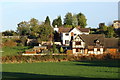
Houses - the northern edge of Woodcroft
Image: © Ruth Sharville
Taken: 26 Oct 2008
0.01 miles
2
![A walk around the east bank of the River Wye [41]](https://s3.geograph.org.uk/geophotos/07/36/30/7363035_020debed_120x120.jpg)
A walk around the east bank of the River Wye [41]
The route heads south along Stoulgrove Lane.
The walk leaves Chepstow, crosses the River Wye, and ascends through Tutshill, following the long distance Offa’s Dyke Path. A diversion down the Lancaut Walk is taken before returning to rejoin Offa’s Dyke Path to Wintour’s Leap. After crossing Coleford Road, B4228, footpaths and roads are taken through Woodcroft and Tutshill to recross the river and return to the starting point. About 5 miles.
Image: © Michael Dibb
Taken: 3 Sep 2022
0.05 miles
3
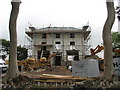
Stoulgrove House re-development
"Alterations and extensions to dwelling and construction of a detached garage/store with ancillary works"
Image: © Roy Parkhouse
Taken: 16 Oct 2009
0.06 miles
4
Oak Cottage, Woodcroft
From Stoulgrove Lane
Image: © Roy Parkhouse
Taken: 16 Oct 2009
0.08 miles
5
![A walk around the east bank of the River Wye [40]](https://s1.geograph.org.uk/geophotos/07/36/30/7363033_f57624ec_120x120.jpg)
A walk around the east bank of the River Wye [40]
No longer following Offa's Dyke Path, the route is now heading south to return to Chepstow.
The walk leaves Chepstow, crosses the River Wye, and ascends through Tutshill, following the long distance Offa’s Dyke Path. A diversion down the Lancaut Walk is taken before returning to rejoin Offa’s Dyke Path to Wintour’s Leap. After crossing Coleford Road, B4228, footpaths and roads are taken through Woodcroft and Tutshill to recross the river and return to the starting point. About 5 miles.
Image: © Michael Dibb
Taken: 3 Sep 2022
0.08 miles
6
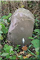
Old Milestone by the B4228, Woodcroft
Carved stone post by the B4228, in parish of Tidenham (Forest of Dean District), opposite No.1 Sunnyside Cottages, on grass verge, on East side of road. Chepstow stone, erected by the Chepstow District Turnpike Trust in the 19th century.
Inscription reads:-
To
Chepstow
(2)
Carved benchmark on front.
Grade II listed. List Entry Number: 1186652
https://historicengland.org.uk/listing/the-list/list-entry/1186652
Milestone Society National ID: GL_CWCO02.
Image: © Milestone Society
Taken: 13 Oct 2018
0.10 miles
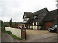
7
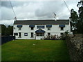
The Rising Sun Pub, Woodcroft
Image: © Nick Mutton 01329 000000
Taken: 14 Sep 2007
0.11 miles
9
![A walk around the east bank of the River Wye [42]](https://s1.geograph.org.uk/geophotos/07/36/30/7363037_ccfeb654_120x120.jpg)
A walk around the east bank of the River Wye [42]
The Rising Sun public house in Woodcroft closed in 2011 and was due to become apartments. However, some 250 local residents have raised money and the Rising Sun re-opened in October, 2022. The plan is to make the Rising Sun a community hub offering a place for local people and groups to meet.
The walk leaves Chepstow, crosses the River Wye, and ascends through Tutshill, following the long distance Offa’s Dyke Path. A diversion down the Lancaut Walk is taken before returning to rejoin Offa’s Dyke Path to Wintour’s Leap. After crossing Coleford Road, B4228, footpaths and roads are taken through Woodcroft and Tutshill to recross the river and return to the starting point. About 5 miles.
Image: © Michael Dibb
Taken: 3 Sep 2022
0.12 miles
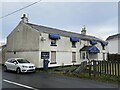
10
Milestone - 2 Miles to Chepstow on the B4228 at Woodcroft
The milestone is half-buried in the left foreground of the photograph. The Rising Sun Public House is in the distance, on the left.
Image: © Roy Parkhouse
Taken: 3 Feb 2006
0.14 miles