IMAGES TAKEN NEAR TO
Tidenham Chase, CHEPSTOW, NP16 7JS
Introduction
This page details the photographs taken nearby to NP16 7JS by members of the Geograph project.
The Geograph project started in 2005 with the aim of publishing, organising and preserving representative images for every square kilometre of Great Britain, Ireland and the Isle of Man.

There are currently over 7.5m images from over14,400 individuals and you can help contribute to the project by visiting https://www.geograph.org.uk
Image Map
Images are licensed for reuse under creativecommons.org/licenses/by-sa/2.0
Notes
- Clicking on the map will re-center to the selected point.
- The higher the marker number, the further away the image location is from the centre of the postcode.
Image Listing (49 Images Found)
Images are licensed for reuse under creativecommons.org/licenses/by-sa/2.0
Image
Details
Distance
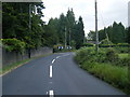
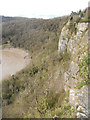
2
Wintour's Leap and the B4228
This photograph shows just how near the precipice cars are without the passengers being aware. The sharp-eyed may notice climbers at top right.
Image: © Roy Parkhouse
Taken: 26 Mar 2005
0.06 miles
3
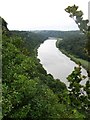
River Wye
River Wye from the top of "Easy Way Down" on Wintour's Leap.
Image: © Richard Smith
Taken: 25 Aug 2008
0.07 miles
4
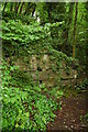
Remains of a wall, Lancaut Wood
This wall is the remains of a ancient stone hut. At Lancaut there used to be a medieval village which was wiped out by the Black Death in the 14th century.
Image: © Philip Halling
Taken: 10 May 2008
0.07 miles
5
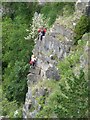
Wintors Leap
Two people enjoying some good climbing on August Bank Holiday 2008
Image: © Richard Smith
Taken: 25 Aug 2008
0.08 miles
6
View towards the cliffs at Broadrock
Image: © Roger Cornfoot
Taken: 12 May 2018
0.09 miles
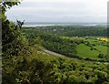
8
Aerial view of River Wye from Woodcroft
Image: © Nick Mutton 01329 000000
Taken: 13 Sep 2008
0.09 miles
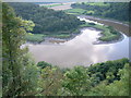
9
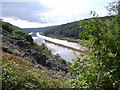
Looking up the River Wye towards Chepstow
Image: © Nick Mutton 01329 000000
Taken: 13 Sep 2008
0.10 miles
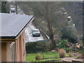
10
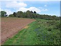
Field south of Netherhope Lane
Offa's Dyke National Trail following field boundary before rejoining the B4228 near Ashberry House, Netherhope Lane
Image: © Chris Heaton
Taken: 7 May 2006
0.10 miles