IMAGES TAKEN NEAR TO
Tidenham, CHEPSTOW, NP16 7JF
Introduction
This page details the photographs taken nearby to NP16 7JF by members of the Geograph project.
The Geograph project started in 2005 with the aim of publishing, organising and preserving representative images for every square kilometre of Great Britain, Ireland and the Isle of Man.

There are currently over 7.5m images from over14,400 individuals and you can help contribute to the project by visiting https://www.geograph.org.uk
Image Map
Images are licensed for reuse under creativecommons.org/licenses/by-sa/2.0
Notes
- Clicking on the map will re-center to the selected point.
- The higher the marker number, the further away the image location is from the centre of the postcode.
Image Listing (28 Images Found)
Images are licensed for reuse under creativecommons.org/licenses/by-sa/2.0
Image
Details
Distance
1
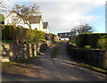
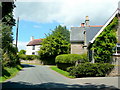
Track past The Old Post Office, Tidenham
Viewed from the main road through the village, opposite Netherhope Lane. http://www.geograph.org.uk/photo/3301474
A nameplate on the left side of the wall shows THE OLD POST OFFICE.
Image: © Jaggery
Taken: 1 Jan 2013
0.02 miles
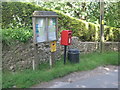
2
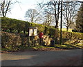
Postbox and village notice board, Tidenham
Tidenham is both a village and a civil parish in the Forest of Dean district in west Gloucestershire.
The village of Tidenham has no real centre or focal point (except perhaps the church). http://www.geograph.org.uk/photo/3280413.
There are no shops or post office. This postbox and notice board is alongside the main road
through the village, viewed from the Netherhope Lane junction. http://www.geograph.org.uk/photo/3301474
Image: © Jaggery
Taken: 1 Jan 2013
0.02 miles
3
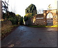
Netherhope Lane, Tidenham
Viewed from the main road through Tidenham.
On the wall of Cross Hill House, a name sign shows TO NETHERHOPE LANE.
Image: © Jaggery
Taken: 1 Jan 2013
0.03 miles
4
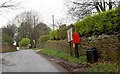
Tidenham postbox and village notice board
Image: © Steve Fareham
Taken: 28 Jan 2009
0.04 miles
5
Tidenham Parish sign and postbox
Notice that the red K6 telephone box shown on the OS maps is no longer there, sadly culled by BT in 2006.
Image: © Nick Mutton 01329 000000
Taken: 10 Jun 2008
0.05 miles
6
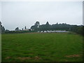
Set-aside in a field near Cross Hill, Tidenham
Not your usual area of set aside but a farm of photovoltaic panels generating electricity for the nearby house, or houses, or sale to the National Grid, or all of the above.
Why spoil the roofline aesthetics of your own roof when you can deposit them in a field nearby!?
Image: © Jeremy Bolwell
Taken: 12 Aug 2012
0.08 miles
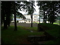
7
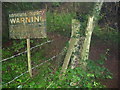
Path corner near Dayhouse Quarry
A really old warning sign is still here.
Image: © Jeremy Bolwell
Taken: 12 Aug 2012
0.11 miles
8
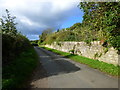
Netherhope Lane, from the junction with Bishton Lane, Tidenham
Image: © Ruth Sharville
Taken: 3 Nov 2013
0.12 miles
9
Cottages at Tidenham
The lane ascends Cross Hill.
Image: © Jonathan Billinger
Taken: 22 Jul 2010
0.15 miles
10
New manor house at Tidenham
A fabulous new build mansion.
Image: © Jeremy Bolwell
Taken: 12 Aug 2012
0.20 miles