IMAGES TAKEN NEAR TO
Sedbury, CHEPSTOW, NP16 7HN
Introduction
This page details the photographs taken nearby to NP16 7HN by members of the Geograph project.
The Geograph project started in 2005 with the aim of publishing, organising and preserving representative images for every square kilometre of Great Britain, Ireland and the Isle of Man.

There are currently over 7.5m images from over14,400 individuals and you can help contribute to the project by visiting https://www.geograph.org.uk
Image Map
Images are licensed for reuse under creativecommons.org/licenses/by-sa/2.0
Notes
- Clicking on the map will re-center to the selected point.
- The higher the marker number, the further away the image location is from the centre of the postcode.
Image Listing (45 Images Found)
Images are licensed for reuse under creativecommons.org/licenses/by-sa/2.0
Image
Details
Distance
1
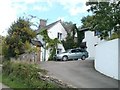
Ivy Cottages, Sedbury Lane
Two ivy-clad semi-detached dwellings named Ivy Cottages, on the east side of Sedbury Lane.
Image: © Jaggery
Taken: 17 Sep 2010
0.02 miles
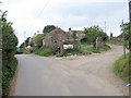
2
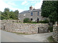
Sedbury Lane cottages
Cottages opposite a T junction. http://www.geograph.org.uk/photo/2140609
Image: © Jaggery
Taken: 17 Sep 2010
0.02 miles
3
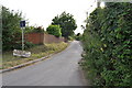
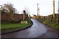
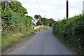
Sedbury Lane junction
Where you see the road flatten out this is where the railway used to cross the lane.
Image: © Nick Mutton 01329 000000
Taken: 29 Jun 2010
0.03 miles
4
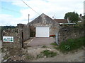
The Old Smithy, Sedbury Lane
Located on the corner of Sedbury Lane and the access road to Tump Farm.
Image: © Jaggery
Taken: 17 Sep 2010
0.04 miles
5
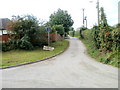
Western arm of Sedbury Lane
An arm of Sedbury Lane heads west away from the main course of the lane. The name sign is supported by two small feet, one of which has sunk into the ground, leaving the sign lopsided. It states
SEDBURY LANE
LEADING TO
ORCHARD LEA, CRANMERE
UPPER SEDBURY HOUSE
ONLY.
Image: © Jaggery
Taken: 17 Sep 2010
0.07 miles
6
Sedbury Lane
Rendered a dead-end by the Tutshill bypass.
Image: © Jonathan Billinger
Taken: 28 Dec 2006
0.07 miles
7
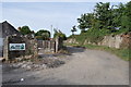
Junction of Sedbury Lane and track to Chepstow Outdoor Activity centre
Image: © Nick Mutton 01329 000000
Taken: 29 Jun 2010
0.09 miles
8
Footpath to Pighole Pill
The road ahead leads to Snipehill Bridge. In the centre of the photograph are Tump Farm Cottages. The footpath leads off to the right, initially following the rough track.
Image: © Roy Parkhouse
Taken: 31 Aug 2007
0.09 miles
10
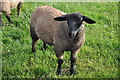
A sheep in a Sedbury field
Image: © Nick Mutton 01329 000000
Taken: 29 Jun 2010
0.09 miles