IMAGES TAKEN NEAR TO
Watchtower Way, CHEPSTOW, NP16 7FG
Introduction
This page details the photographs taken nearby to Watchtower Way, NP16 7FG by members of the Geograph project.
The Geograph project started in 2005 with the aim of publishing, organising and preserving representative images for every square kilometre of Great Britain, Ireland and the Isle of Man.

There are currently over 7.5m images from over14,400 individuals and you can help contribute to the project by visiting https://www.geograph.org.uk
Image Map
Images are licensed for reuse under creativecommons.org/licenses/by-sa/2.0
Notes
- Clicking on the map will re-center to the selected point.
- The higher the marker number, the further away the image location is from the centre of the postcode.
Image Listing (184 Images Found)
Images are licensed for reuse under creativecommons.org/licenses/by-sa/2.0
Image
Details
Distance
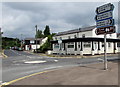
1
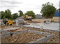
Prestigious development
This used to be the site of a garage for many years but now it's a prime redevelopment area. See Image] for another view.
Image: © Neil Owen
Taken: 16 Jun 2014
0.00 miles
2
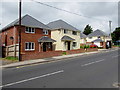
Watchtower Way houses, Tutshill
Recently built houses viewed across Beachley Road in July 2016.
Image: © Jaggery
Taken: 7 Jul 2016
0.01 miles
3
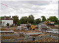
New homes in Tutshill
This will become a small development of five three-and-four bedroomed detached houses. See Image] for another view.
Image: © Neil Owen
Taken: 16 Jun 2014
0.01 miles
4

Beachley Road bus stop and shelter, Tutshill
This stop for buses to Chepstow is near recently-built houses in Watchtower Way, viewed in July 2016.
Image: © Jaggery
Taken: 7 Jul 2016
0.01 miles
5
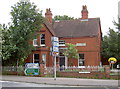
The blue light has gone out
This building is a former Gloucestershire Constabulary police station. It was founded in the early 1900s but is now no longer part of the force. On the side (right of shot) is a flush bracket - see Image
Image: © Neil Owen
Taken: 16 Jun 2014
0.02 miles
6
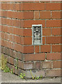
Police station flush bracket
Number S1358, on the side of a former Gloucester Police station. See http://www.bench-marks.org.uk/bm10736 for the entry in the Benchmark Database and Image] for a wider view.
Image: © Neil Owen
Taken: 16 Jun 2014
0.02 miles
7
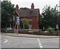
Former police station, Tutshill
The building on the corner of Gloucester Road and Beachley Road is now in residential use.
A Gloucestershire Constabulary plaque http://www.geograph.org.uk/photo/5602940 remains on the building in July 2016.
Image: © Jaggery
Taken: 7 Jul 2016
0.02 miles
8
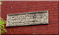
Gloucestershire Constabulary plaque, Tutshill
On this http://www.geograph.org.uk/photo/5602935 former police station.
Image: © Jaggery
Taken: 7 Jul 2016
0.02 miles
9
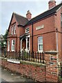
Gloucestershire Constabulary
Former police house or police station in Tutshill. Now a private house.
Image: © Alan Hughes
Taken: 12 Dec 2021
0.02 miles
10
Directions and distances signs, Gloucester Road, Tutshill
Near twin roundabouts at crossroads.
Image: © Jaggery
Taken: 7 Jul 2016
0.02 miles