IMAGES TAKEN NEAR TO
The Gardens, CHEPSTOW, NP16 7FF
Introduction
This page details the photographs taken nearby to The Gardens, NP16 7FF by members of the Geograph project.
The Geograph project started in 2005 with the aim of publishing, organising and preserving representative images for every square kilometre of Great Britain, Ireland and the Isle of Man.

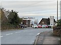
There are currently over 7.5m images from over14,400 individuals and you can help contribute to the project by visiting https://www.geograph.org.uk
Image Map
Images are licensed for reuse under creativecommons.org/licenses/by-sa/2.0
Notes
- Clicking on the map will re-center to the selected point.
- The higher the marker number, the further away the image location is from the centre of the postcode.
Image Listing (127 Images Found)
Images are licensed for reuse under creativecommons.org/licenses/by-sa/2.0
Image
Details
Distance
2
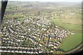
![A walk around the east bank of the River Wye [52]](https://s3.geograph.org.uk/geophotos/07/36/37/7363755_3f35a3bb_120x120.jpg)
A walk around the east bank of the River Wye [52]
The route follows Elm Road to Gloucester Road, B4228.
The walk leaves Chepstow, crosses the River Wye, and ascends through Tutshill, following the long distance Offa’s Dyke Path. A diversion down the Lancaut Walk is taken before returning to rejoin Offa’s Dyke Path to Wintour’s Leap. After crossing Coleford Road, B4228, footpaths and roads are taken through Woodcroft and Tutshill to recross the river and return to the starting point. About 5 miles.
Image: © Michael Dibb
Taken: 3 Sep 2022
0.06 miles
3
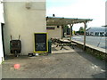
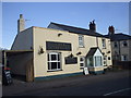
The Cross Keys Pub, Tutshill - Front Beer Garden
Looking across the front beer garden to the roundabout and empty car sales garage on corner of Beachley Road.
Image: © Nick Mutton 01329 000000
Taken: 18 Sep 2007
0.06 miles
4
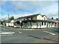
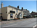
The Cross Keys pub, Tutshill
This is a proper pub, good beer and well located.
Image: © Nick Mutton 01329 000000
Taken: 14 Sep 2007
0.07 miles
5
Gloucester Road, Tutshill
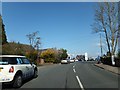
The road close to the Fiat dealers and garage
Image: © David Smith
Taken: 16 Apr 2013
0.07 miles
6
Corner of Silley's Close and Coleford Road, Tutshill
Viewed across the B4228 Coleford Road. Silley's Close is a short cul-de-sac of 14 houses.
Image: © Jaggery
Taken: 12 May 2013
0.07 miles
8
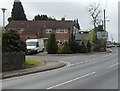
The Live & Let Live Inn
Coleford Road, Tutshill (the B4228)
Image: © Roy Parkhouse
Taken: 11 Aug 2007
0.07 miles
9
Milestone outside The Cross Keys pub, Tutshill
This is an original milestone outside the pub.
Image: © Nick Mutton 01329 000000
Taken: 18 Sep 2007
0.07 miles