1
Former Cross Keys pub on a Tutshill corner
On the corner of Coleford Road and Gloucester Road, viewed in July 2016 when the building is in residential use. This http://www.geograph.org.uk/photo/555068 September 2007 photo shows the pub.
Image: © Jaggery
Taken: 7 Jul 2016
0.01 miles
2
Old Milestone by the B4228, Coleford Road, Tutshill
Carved stone post with missing attachment, on Coleford Road, Tutshill, Tidenham, Forest of Dean District. In garden of former Cross Keys PH, now apartments, against wall. Originally south of the crossroads in Beachley Road, against the police station boundary wall, east side of road. Chepstow stone, erected by the Chepstow District Turnpike Trust in the 19th century.
Painted inscription reads:-
To
Chepstow
1
Mile
Milestone Society National ID: GL_CWCO01.
Image: © Milestone Society
Taken: 13 Oct 2018
0.01 miles
3
Cross Keys at the crossroads
The unusual style of building belies the fact that this was the former Cross Keys pub. The watering hole was opened well over a century ago but was converted into flats only very recently.
Image: © Neil Owen
Taken: 16 Jun 2014
0.01 miles
4
B4228 Coleford Road
Image: © Alan Hughes
Taken: 12 Dec 2021
0.01 miles
5
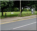
BT phonebox, Coleford Road, Tutshill
Near a recreation ground entrance.
Image: © Jaggery
Taken: 7 Jul 2016
0.02 miles
6
Ordnance Survey Flush Bracket S1358
This can be found on the wall of a former Police Station - now a private dwelling - in Tutshill.
For more detail see :
Image: © Peter Wood
Taken: 16 Oct 2016
0.02 miles
7
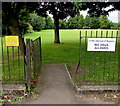
In the interest of Hygiene, NO DOGS ALLOWED in Tutshill recreation ground
On the left here, http://www.geograph.org.uk/photo/5603267 the notice is at the Coleford Road entrance to the recreation ground. The Tidenham War Memorial and Recreation Trust yellow notice on the left states RECREATION GROUND OPEN TO THE PUBLIC. NO DOGS. NO LITTERING. NO CAMPING. NO FIRES. ANTISOCIAL BEHAVIOUR WILL BE REPORTED TO THE POLICE.
Image: © Jaggery
Taken: 7 Jul 2016
0.02 miles
8
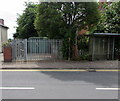
Gloucester Road electricity substation, Tutshill
The Western Power Distribution electricity substation is in a fenced
enclosure on the south side of Gloucester Road near a bus stop and shelter.
Image: © Jaggery
Taken: 7 Jul 2016
0.02 miles
9
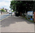
Directions and distances signs, Gloucester Road, Tutshill
Near twin roundabouts at crossroads.
Image: © Jaggery
Taken: 7 Jul 2016
0.02 miles
10
Gloucester Road direction and distances signs, Tutshill
6 miles from Alvington, 8 from Lydney.
Image: © Jaggery
Taken: 7 Jul 2016
0.02 miles


