IMAGES TAKEN NEAR TO
Wyebank Place, CHEPSTOW, NP16 7EU
Introduction
This page details the photographs taken nearby to Wyebank Place, NP16 7EU by members of the Geograph project.
The Geograph project started in 2005 with the aim of publishing, organising and preserving representative images for every square kilometre of Great Britain, Ireland and the Isle of Man.

There are currently over 7.5m images from over14,400 individuals and you can help contribute to the project by visiting https://www.geograph.org.uk
Image Map
Images are licensed for reuse under creativecommons.org/licenses/by-sa/2.0
Notes
- Clicking on the map will re-center to the selected point.
- The higher the marker number, the further away the image location is from the centre of the postcode.
Image Listing (42 Images Found)
Images are licensed for reuse under creativecommons.org/licenses/by-sa/2.0
Image
Details
Distance
1
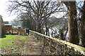
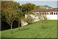
Offas Dyke path
River Wye on the right.
Image: © Clive Perrin
Taken: 9 Mar 2014
0.07 miles
2
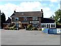
The Fisherman, Sedbury
The pub building is set back 40 metres from the south side of Beachley Road, facing Grahamstown Road.
The exterior of the pub looked like this http://www.geograph.org.uk/photo/300587 four years previously.
Image: © Jaggery
Taken: 17 Sep 2010
0.11 miles
3
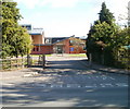
Vehicle exit road from Wyedean School, Sedbury
Pedestrians can of course enter the school here, but for vehicles this is an exit route only. However, the white NO ENTRY on the road surface is faded, and the no entry sign on the right is partly obscured by a hedge.
Image: © Jaggery
Taken: 17 Sep 2010
0.11 miles
6
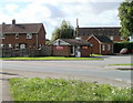
Marmaris Kebab House, Sedbury
Takeaway located on Beachley Road, at the eastern corner of a site set back from the road. The centre of the site is occupied by The Fisherman http://www.geograph.org.uk/photo/2073975 pub.
Image: © Jaggery
Taken: 17 Sep 2010
0.17 miles
7
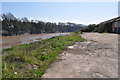
Wasteland on the bank of the River Wye, Chepstow
This land is ready for redevelopment
Image: © Nick Mutton 01329 000000
Taken: 18 Apr 2010
0.17 miles
8
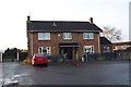
The Fisherman
Like most of the 'village' of Sedbury, a creation of the 1960's.
Image: © Jonathan Billinger
Taken: 28 Dec 2006
0.17 miles
9
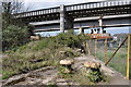
Bridges, boats, fences and moorings
Wasteland on the bank of the River Wye. Ready for development
Image: © Nick Mutton 01329 000000
Taken: 18 Apr 2010
0.19 miles
10
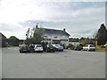
Sedbury, Village Inn
Welcoming public house on Beachley Road. Central counter, with drinking area front, and eating left and right; garden, TV, games machines. Cask ale on offer: Sharp's Doom Bar.
Image: © Mike Faherty
Taken: 13 Oct 2018
0.20 miles