IMAGES TAKEN NEAR TO
Wyebank Road, CHEPSTOW, NP16 7ER
Introduction
This page details the photographs taken nearby to Wyebank Road, NP16 7ER by members of the Geograph project.
The Geograph project started in 2005 with the aim of publishing, organising and preserving representative images for every square kilometre of Great Britain, Ireland and the Isle of Man.

There are currently over 7.5m images from over14,400 individuals and you can help contribute to the project by visiting https://www.geograph.org.uk
Image Map
Images are licensed for reuse under creativecommons.org/licenses/by-sa/2.0
Notes
- Clicking on the map will re-center to the selected point.
- The higher the marker number, the further away the image location is from the centre of the postcode.
Image Listing (90 Images Found)
Images are licensed for reuse under creativecommons.org/licenses/by-sa/2.0
Image
Details
Distance
4
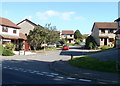
Offa's Dyke Path entering Wyebank Avenue
The National Trial entering a housing estate in Sedbury - a community on the English side of the River Wye opposite Chepstow
Image: © Chris Heaton
Taken: 11 Feb 2016
0.12 miles
5
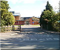
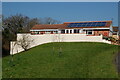
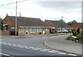
Vehicle exit road from Wyedean School, Sedbury
Pedestrians can of course enter the school here, but for vehicles this is an exit route only. However, the white NO ENTRY on the road surface is faded, and the no entry sign on the right is partly obscured by a hedge.
Image: © Jaggery
Taken: 17 Sep 2010
0.12 miles
6
Part of Offa's Dyke Path passing through Sedbury
After walking so much of the dyke in so many different environments from heather moorland, nature reserve woodland, upland ridges, river valleys and pine plantations it is a bit surreal to find yourself nearing the finish of the walk in a suburban housing estate.
Image: © Jeremy Bolwell
Taken: 7 Sep 2010
0.13 miles
7
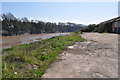
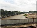
Wasteland on the bank of the River Wye, Chepstow
This land is ready for redevelopment
Image: © Nick Mutton 01329 000000
Taken: 18 Apr 2010
0.13 miles
8
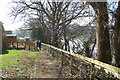
Offas Dyke path
River Wye on the right.
Image: © Clive Perrin
Taken: 9 Mar 2014
0.13 miles
9
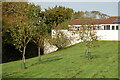
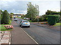
The Martins, Sedbury
The Martins is an area of about 60 modern houses, on the east side of Beachley Road.
Image: © Jaggery
Taken: 17 Sep 2010
0.14 miles
10
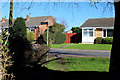
Wyebank Avenue, Sedbury
Viewed across Beachley Road.
Although name signs in the area clearly put Wyebank Avenue in Sedbury, many online references put it in Tutshill. A further confusing factor is that Wyebank Avenue, in England, has Chepstow in Wales as its postal town, and an NP16 (Newport area) post code.
Image: © Jaggery
Taken: 8 Sep 2010
0.14 miles