IMAGES TAKEN NEAR TO
Bigstone Grove, CHEPSTOW, NP16 7EN
Introduction
This page details the photographs taken nearby to Bigstone Grove, NP16 7EN by members of the Geograph project.
The Geograph project started in 2005 with the aim of publishing, organising and preserving representative images for every square kilometre of Great Britain, Ireland and the Isle of Man.

There are currently over 7.5m images from over14,400 individuals and you can help contribute to the project by visiting https://www.geograph.org.uk
Image Map
Images are licensed for reuse under creativecommons.org/licenses/by-sa/2.0
Notes
- Clicking on the map will re-center to the selected point.
- The higher the marker number, the further away the image location is from the centre of the postcode.
Image Listing (155 Images Found)
Images are licensed for reuse under creativecommons.org/licenses/by-sa/2.0
Image
Details
Distance
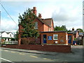
1
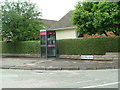
Tutshill (Junction of Sedbury Lane & Bigstone Grove)
This public payphone is at the junction of Sedbury Lane & Bigstone Grove.
Image: © Nick Mutton 01329 000000
Taken: 24 Jun 2007
0.07 miles
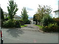
2
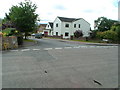
Junction of Sedbury Lane & Castle View
Image: © Nick Mutton 01329 000000
Taken: 14 Sep 2007
0.08 miles
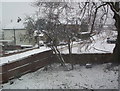
3
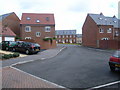
Bigstone Meadow
Looking in to the middle of Bigstone Meadow from Myrtles exit.
=== This is the first picture taken with my new RICOH 500SE GPS camera ===
Image: © Nick Mutton 01329 000000
Taken: 22 Sep 2007
0.09 miles
4
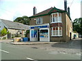
Tutshill village shop, Beachley Road
This is Tutshill's village shop
Image: © Nick Mutton 01329 000000
Taken: 14 Sep 2007
0.10 miles
5
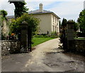
![A walk around the east bank of the River Wye [56]](https://s1.geograph.org.uk/geophotos/07/36/37/7363761_4c862c2b_120x120.jpg)
A walk around the east bank of the River Wye [56]
Tutshill Lodge, Beachley Road, is an early 19th century Regency villa. Constructed of stuccoed brick under a Welsh slate roof. Some original internal features and fittings remain. Listed, grade II, with details at: https://historicengland.org.uk/listing/the-list/list-entry/1186657
The walk leaves Chepstow, crosses the River Wye, and ascends through Tutshill, following the long distance Offa’s Dyke Path. A diversion down the Lancaut Walk is taken before returning to rejoin Offa’s Dyke Path to Wintour’s Leap. After crossing Coleford Road, B4228, footpaths and roads are taken through Woodcroft and Tutshill to recross the river and return to the starting point. About 5 miles.
Image: © Michael Dibb
Taken: 3 Sep 2022
0.10 miles
7
Tutshill (Junction of Sedbury Lane & The Myrtles)
Very cold day, picture taken from one of our 2nd floor windows.
Image: © Nick Mutton 01329 000000
Taken: 9 Feb 2007
0.10 miles
9
View of Tutshill Gardens from Sedbury Lane
Image: © Nick Mutton 01329 000000
Taken: 14 Sep 2007
0.10 miles
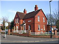
10
Grade II listed Tutshill Lodge, Tutshill
The Regency villa (early 19th century) was Grade II listed in 1988.
Image: © Jaggery
Taken: 7 Jul 2016
0.11 miles