IMAGES TAKEN NEAR TO
Beachley Road, CHEPSTOW, NP16 7DT
Introduction
This page details the photographs taken nearby to Beachley Road, NP16 7DT by members of the Geograph project.
The Geograph project started in 2005 with the aim of publishing, organising and preserving representative images for every square kilometre of Great Britain, Ireland and the Isle of Man.

There are currently over 7.5m images from over14,400 individuals and you can help contribute to the project by visiting https://www.geograph.org.uk
Image Map
Images are licensed for reuse under creativecommons.org/licenses/by-sa/2.0
Notes
- Clicking on the map will re-center to the selected point.
- The higher the marker number, the further away the image location is from the centre of the postcode.
Image Listing (91 Images Found)
Images are licensed for reuse under creativecommons.org/licenses/by-sa/2.0
Image
Details
Distance
1
Mobile phone mast, Sedbury
Viewed from Beachley Road. The 23 metre high mast is behind Wyedean School buildings.
Image: © Jaggery
Taken: 17 Sep 2010
0.08 miles
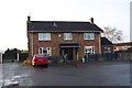
2
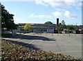
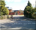
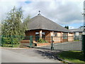
Primary school entrance road, Sedbury
Located on the opposite side of Beachley Road from Wyedean School. http://www.geograph.org.uk/photo/2073863
Offa's Mead Primary School has about 150 pupils, ages from 4 to 11.
Image: © Jaggery
Taken: 17 Sep 2010
0.08 miles
3
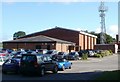
Wyedean School, Sedbury
Wyedean School and Sixth Form Centre occupies a site on the NE side of Beachley Road, west of Grahamstown Road. It is a mixed comprehensive school, with more than 1200 pupils including 250 in the sixth form. First set up in 1973, the school moved here in 1976.
A notable former pupil is J K Rowling, who later achieved worldwide fame as the author of the Harry Potter fantasy series. She was head girl here in 1982.
Image: © Jaggery
Taken: 17 Sep 2010
0.08 miles
4
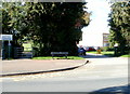
Vehicle exit road from Wyedean School, Sedbury
Pedestrians can of course enter the school here, but for vehicles this is an exit route only. However, the white NO ENTRY on the road surface is faded, and the no entry sign on the right is partly obscured by a hedge.
Image: © Jaggery
Taken: 17 Sep 2010
0.10 miles
5
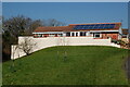
The Fisherman
Like most of the 'village' of Sedbury, a creation of the 1960's.
Image: © Jonathan Billinger
Taken: 28 Dec 2006
0.12 miles
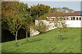
7
Part of Offa's Dyke Path passing through Sedbury
After walking so much of the dyke in so many different environments from heather moorland, nature reserve woodland, upland ridges, river valleys and pine plantations it is a bit surreal to find yourself nearing the finish of the walk in a suburban housing estate.
Image: © Jeremy Bolwell
Taken: 7 Sep 2010
0.13 miles
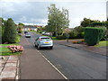
9
Offa's Dyke Path entering Wyebank Avenue
The National Trial entering a housing estate in Sedbury - a community on the English side of the River Wye opposite Chepstow
Image: © Chris Heaton
Taken: 11 Feb 2016
0.13 miles
10
Sacred Heart Chapel, Sedbury
A Roman Catholic chapel located in a fenced-off enclosure at the corner of Grahamstown Road and Edmond Road. The chapel is part of Gloucester Deanery, Clifton Diocese.
Image: © Jaggery
Taken: 17 Sep 2010
0.14 miles