IMAGES TAKEN NEAR TO
Beachley Road, CHEPSTOW, NP16 7DL
Introduction
This page details the photographs taken nearby to Beachley Road, NP16 7DL by members of the Geograph project.
The Geograph project started in 2005 with the aim of publishing, organising and preserving representative images for every square kilometre of Great Britain, Ireland and the Isle of Man.

There are currently over 7.5m images from over14,400 individuals and you can help contribute to the project by visiting https://www.geograph.org.uk
Image Map
Images are licensed for reuse under creativecommons.org/licenses/by-sa/2.0
Notes
- Clicking on the map will re-center to the selected point.
- The higher the marker number, the further away the image location is from the centre of the postcode.
Image Listing (453 Images Found)
Images are licensed for reuse under creativecommons.org/licenses/by-sa/2.0
Image
Details
Distance
1
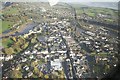
Chepstow Town
The High Street through the old part of the town shows up clearly with the A48 and Railway top right.
Image: © Peter Randall-Cook
Taken: 30 Nov 2013
0.03 miles
2
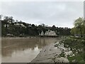
Looking across the River Wye to England
Image: © Nick Mutton 01329 000000
Taken: 18 Apr 2010
0.03 miles
3
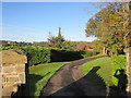
Offa's Dyke Path Off Beachley Road Tutshill
Image: © Roy Hughes
Taken: 27 Oct 2017
0.03 miles
4
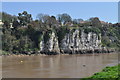
Limestone cliff with square cave
Across the Wye from Chepstow, and therefore in Gloucestershire, the mark on the cliff shows the tidal nature of the River Wye at this point. The small square opening, known as 'The Gloucester Hole' leads into a large chamber and there are many stories concerning its origin and subsequent use including an explosives store during the building of the railway by Brunel, or a tea store.
A plaque/tile nearby offers an explanation. It was once fitted with a crane and probably used to unload larger ships that were able to moor in the deeper water on that side of the river.
Image: © Pauline E
Taken: 24 Feb 2008
0.04 miles
5
![A walk around the east bank of the River Wye [57]](https://s0.geograph.org.uk/geophotos/07/36/37/7363764_01fa19d2_120x120.jpg)
A walk around the east bank of the River Wye [57]
Gate piers, gates and boundary walls of Tutshill Lodge were erected in the early 19th century. Sandstone walls and iron gates. Listed, grade II, with details at: https://historicengland.org.uk/listing/the-list/list-entry/1186658
The walk leaves Chepstow, crosses the River Wye, and ascends through Tutshill, following the long distance Offa’s Dyke Path. A diversion down the Lancaut Walk is taken before returning to rejoin Offa’s Dyke Path to Wintour’s Leap. After crossing Coleford Road, B4228, footpaths and roads are taken through Woodcroft and Tutshill to recross the river and return to the starting point. About 5 miles.
Image: © Michael Dibb
Taken: 3 Sep 2022
0.04 miles
6
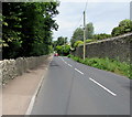
Stone walls, Beachley Road, Tutshill
This part of Beachley Road is between Rock Villa Lane and Sedbury Lane.
Image: © Jaggery
Taken: 7 Jul 2016
0.04 miles
9

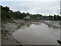
Roundabout at junction of Sedbury Lane & Beachley Road
Image: © Nick Mutton 01329 000000
Taken: 14 Sep 2007
0.05 miles
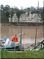
10
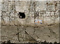
A face at the 'window'
Someone appears at the 'Gloucester Hole', but presumably will not be repainting the old flag - having been first made in 1935 to commemorate the Silver Jubilee of George V.
Image: © Neil Owen
Taken: 7 Aug 2013
0.05 miles