IMAGES TAKEN NEAR TO
Gloucester Road, CHEPSTOW, NP16 7DB
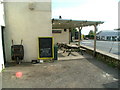
Introduction
This page details the photographs taken nearby to Gloucester Road, NP16 7DB by members of the Geograph project.
The Geograph project started in 2005 with the aim of publishing, organising and preserving representative images for every square kilometre of Great Britain, Ireland and the Isle of Man.

There are currently over 7.5m images from over14,400 individuals and you can help contribute to the project by visiting https://www.geograph.org.uk
Image Map
Images are licensed for reuse under creativecommons.org/licenses/by-sa/2.0
Notes
- Clicking on the map will re-center to the selected point.
- The higher the marker number, the further away the image location is from the centre of the postcode.
Image Listing (139 Images Found)
Images are licensed for reuse under creativecommons.org/licenses/by-sa/2.0
Image
Details
Distance
1
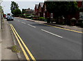
End of the no parking zone, Gloucester Road, Tutshill
The double yellow lines mark the zone where parking is illegal at any time.
Image: © Jaggery
Taken: 7 Jul 2016
0.01 miles
2
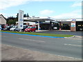
Motor Services, Tutshill
Located on Gloucester Road. Fiat dealers, also selling and servicing all makes. The premises are also an MoT test centre.
Image: © Jaggery
Taken: 17 Sep 2010
0.01 miles
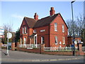
3
Milestone outside The Cross Keys pub, Tutshill
This is an original milestone outside the pub.
Image: © Nick Mutton 01329 000000
Taken: 18 Sep 2007
0.03 miles
4
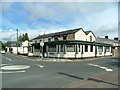
The Cross Keys pub, Tutshill
This is a proper pub, good beer and well located.
Image: © Nick Mutton 01329 000000
Taken: 14 Sep 2007
0.03 miles
5
The Cross Keys Pub, Tutshill - Front Beer Garden
Looking across the front beer garden to the roundabout and empty car sales garage on corner of Beachley Road.
Image: © Nick Mutton 01329 000000
Taken: 18 Sep 2007
0.04 miles
6
Gloucester Road electricity substation, Tutshill
The Western Power Distribution electricity substation is in a fenced
enclosure on the south side of Gloucester Road near a bus stop and shelter.
Image: © Jaggery
Taken: 7 Jul 2016
0.04 miles
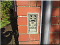
8
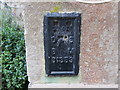
Ordnance Survey Flush Bracket S1359
This can be found on the wall of a private dwelling in Gloucester Road, Tutshill.
For more detail see : http://www.bench-marks.org.uk/bm16017
Image: © Peter Wood
Taken: 16 Oct 2016
0.04 miles
9
Ordnance Survey Flush Bracket S1358
This can be found on the wall of a former Police Station - now a private dwelling - in Tutshill.
For more detail see :
Image: © Peter Wood
Taken: 16 Oct 2016
0.04 miles
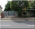
10
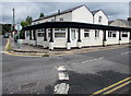
Former Cross Keys pub on a Tutshill corner
On the corner of Coleford Road and Gloucester Road, viewed in July 2016 when the building is in residential use. This http://www.geograph.org.uk/photo/555068 September 2007 photo shows the pub.
Image: © Jaggery
Taken: 7 Jul 2016
0.04 miles