IMAGES TAKEN NEAR TO
Coleford Road, CHEPSTOW, NP16 7BU
Introduction
This page details the photographs taken nearby to Coleford Road, NP16 7BU by members of the Geograph project.
The Geograph project started in 2005 with the aim of publishing, organising and preserving representative images for every square kilometre of Great Britain, Ireland and the Isle of Man.

There are currently over 7.5m images from over14,400 individuals and you can help contribute to the project by visiting https://www.geograph.org.uk
Image Map
Images are licensed for reuse under creativecommons.org/licenses/by-sa/2.0
Notes
- Clicking on the map will re-center to the selected point.
- The higher the marker number, the further away the image location is from the centre of the postcode.
Image Listing (103 Images Found)
Images are licensed for reuse under creativecommons.org/licenses/by-sa/2.0
Image
Details
Distance
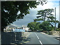
1
![A walk around the east bank of the River Wye [50]](https://s0.geograph.org.uk/geophotos/07/36/37/7363752_84cb153a_120x120.jpg)
A walk around the east bank of the River Wye [50]
The path runs between houses towards Elm Road, Tutshill.
The walk leaves Chepstow, crosses the River Wye, and ascends through Tutshill, following the long distance Offa’s Dyke Path. A diversion down the Lancaut Walk is taken before returning to rejoin Offa’s Dyke Path to Wintour’s Leap. After crossing Coleford Road, B4228, footpaths and roads are taken through Woodcroft and Tutshill to recross the river and return to the starting point. About 5 miles.
Image: © Michael Dibb
Taken: 3 Sep 2022
0.01 miles
2
![A walk around the east bank of the River Wye [51]](https://s1.geograph.org.uk/geophotos/07/36/37/7363753_55771aa9_120x120.jpg)
A walk around the east bank of the River Wye [51]
The path meets Elm Road, Tutshill.
The walk leaves Chepstow, crosses the River Wye, and ascends through Tutshill, following the long distance Offa’s Dyke Path. A diversion down the Lancaut Walk is taken before returning to rejoin Offa’s Dyke Path to Wintour’s Leap. After crossing Coleford Road, B4228, footpaths and roads are taken through Woodcroft and Tutshill to recross the river and return to the starting point. About 5 miles.
Image: © Michael Dibb
Taken: 3 Sep 2022
0.02 miles
3
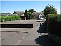
Signpost on the Gloucestershire Way in Elm Rd
Tutshill. The signpost is hard against the cypress tree in the centre of the picture and is pointing left, behind the houses, where it leads to Image and Image
Image: © Roy Parkhouse
Taken: 11 Aug 2007
0.03 miles
4
Looking down Elm Road from Coleford Road
Image: © Nick Mutton 01329 000000
Taken: 6 Jul 2010
0.04 miles
5
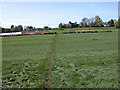
Market Garden on the Gloucestershire Way
Looking towards Tutshill.
Image: © Roy Parkhouse
Taken: 29 Apr 2005
0.06 miles
6
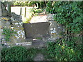
Stone stile on the Gloucestershire Way
The footpath runs behind a row of houses into Elm Road before joining the B4228.
See Image
Image: © Roy Parkhouse
Taken: 11 Aug 2007
0.06 miles
7
![A walk around the east bank of the River Wye [49]](https://s3.geograph.org.uk/geophotos/07/36/37/7363751_1ef0be82_120x120.jpg)
A walk around the east bank of the River Wye [49]
The path, now part of the long distance Gloucestershire Way, passes over this slab stile to run between houses towards Elm Road, Tutshill.
The walk leaves Chepstow, crosses the River Wye, and ascends through Tutshill, following the long distance Offa’s Dyke Path. A diversion down the Lancaut Walk is taken before returning to rejoin Offa’s Dyke Path to Wintour’s Leap. After crossing Coleford Road, B4228, footpaths and roads are taken through Woodcroft and Tutshill to recross the river and return to the starting point. About 5 miles.
Image: © Michael Dibb
Taken: 3 Sep 2022
0.08 miles
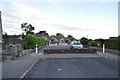
8
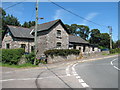
The house where J.K. Rowling lived
You can see where the idea for Hogwarts came from.
Image: © Nick Mutton 01329 000000
Taken: 6 Jul 2010
0.09 miles
9
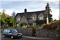
Tidenham War Memorial Hall
Coleford Road, Tutshill.
This is also the road junction of Mopla Road (on the left) with the B4228. The Gloucestershire Way, a Long Distance Footpath, passes through this junction, leaving tarmac some yards further along the Coleford Rd : Image
Image: © Roy Parkhouse
Taken: 11 Aug 2007
0.10 miles