IMAGES TAKEN NEAR TO
Coleford Road, CHEPSTOW, NP16 7BS
Introduction
This page details the photographs taken nearby to Coleford Road, NP16 7BS by members of the Geograph project.
The Geograph project started in 2005 with the aim of publishing, organising and preserving representative images for every square kilometre of Great Britain, Ireland and the Isle of Man.

There are currently over 7.5m images from over14,400 individuals and you can help contribute to the project by visiting https://www.geograph.org.uk
Image Map
Images are licensed for reuse under creativecommons.org/licenses/by-sa/2.0
Notes
- Clicking on the map will re-center to the selected point.
- The higher the marker number, the further away the image location is from the centre of the postcode.
Image Listing (129 Images Found)
Images are licensed for reuse under creativecommons.org/licenses/by-sa/2.0
Image
Details
Distance
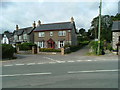
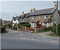
1
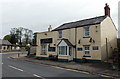
Live & Let Live, Tutshill
The pub is located alongside the B4228 Coleford Road, near the bend at the Mopla Road junction.
Image: © Jaggery
Taken: 12 May 2013
0.01 miles
2
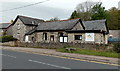
Tidenham War Memorial Hall, Tutshill
Viewed across the B4228 Coleford Road. Part of the hall is a schoolroom which is used by Tutshill Community Pre-School. Their banner is on the right side of the building.
Tutshill is a small village within the parish of Tidenham in the Forest of Dean district of Gloucestershire.
Image: © Jaggery
Taken: 12 May 2013
0.01 miles
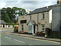
3
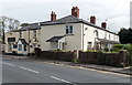
Gower Cottages, Tutshill
Viewed across the B4228 Coleford Road. On the right are Gower Cottages, a row of six dwellings.
On the left is Live & Let Live. http://www.geograph.org.uk/photo/3456263
Image: © Jaggery
Taken: 12 May 2013
0.01 miles
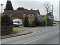
4
Tidenham War Memorial Hall
Coleford Road, Tutshill.
This is also the road junction of Mopla Road (on the left) with the B4228. The Gloucestershire Way, a Long Distance Footpath, passes through this junction, leaving tarmac some yards further along the Coleford Rd : Image
Image: © Roy Parkhouse
Taken: 11 Aug 2007
0.02 miles
5
Junction of Coleford Road & Mopla Road
Image: © Nick Mutton 01329 000000
Taken: 14 Sep 2007
0.03 miles
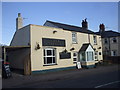
6
The Live & Let Live Pub, Tutshill
This is Tutshill's other pub.
Image: © Nick Mutton 01329 000000
Taken: 14 Sep 2007
0.03 miles
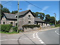
7
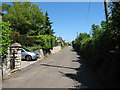
Mopla Road, Tutshill
The junction with the B4228 can be seen in the distance : Image
Image: © Roy Parkhouse
Taken: 11 Aug 2007
0.03 miles
9
Mopla Road, Tutshill
Viewed across the B4228 Coleford Road.
Image: © Jaggery
Taken: 12 May 2013
0.04 miles
10
Corner of Silley's Close and Coleford Road, Tutshill
Viewed across the B4228 Coleford Road. Silley's Close is a short cul-de-sac of 14 houses.
Image: © Jaggery
Taken: 12 May 2013
0.05 miles