IMAGES TAKEN NEAR TO
Bridget Drive, CHEPSTOW, NP16 7AR
Introduction
This page details the photographs taken nearby to Bridget Drive, NP16 7AR by members of the Geograph project.
The Geograph project started in 2005 with the aim of publishing, organising and preserving representative images for every square kilometre of Great Britain, Ireland and the Isle of Man.

There are currently over 7.5m images from over14,400 individuals and you can help contribute to the project by visiting https://www.geograph.org.uk
Image Map
Images are licensed for reuse under creativecommons.org/licenses/by-sa/2.0
Notes
- Clicking on the map will re-center to the selected point.
- The higher the marker number, the further away the image location is from the centre of the postcode.
Image Listing (47 Images Found)
Images are licensed for reuse under creativecommons.org/licenses/by-sa/2.0
Image
Details
Distance
1
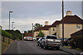
Mercian Way, Pennsylvania Village
Image: © Nick Mutton 01329 000000
Taken: 29 Jun 2010
0.05 miles
3
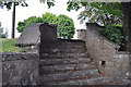
Stone steps at junction of Mercian Way and King Alfreds Road
Image: © Nick Mutton 01329 000000
Taken: 29 Jun 2010
0.06 miles
5

Junction of Mercian Way and Offas Close
Image: © Nick Mutton 01329 000000
Taken: 29 Jun 2010
0.06 miles
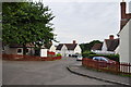
6
Looking along King Alfreds Road from Mercian Way
Image: © Nick Mutton 01329 000000
Taken: 29 Jun 2010
0.06 miles
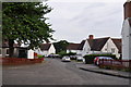
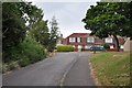
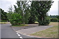
7
Junction of Mercian Way and Bridget Drive
Image: © Nick Mutton 01329 000000
Taken: 29 Jun 2010
0.06 miles
9
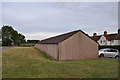
Prefab garages in King Alfreds Road
Image: © Nick Mutton 01329 000000
Taken: 29 Jun 2010
0.08 miles
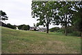
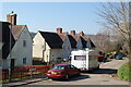
10
Driveway to the old second world war gas mask hut
Image: © Nick Mutton 01329 000000
Taken: 29 Jun 2010
0.09 miles