IMAGES TAKEN NEAR TO
Tylers Way, CHEPSTOW, NP16 7AB
Introduction
This page details the photographs taken nearby to Tylers Way, NP16 7AB by members of the Geograph project.
The Geograph project started in 2005 with the aim of publishing, organising and preserving representative images for every square kilometre of Great Britain, Ireland and the Isle of Man.

There are currently over 7.5m images from over14,400 individuals and you can help contribute to the project by visiting https://www.geograph.org.uk
Image Map
Images are licensed for reuse under creativecommons.org/licenses/by-sa/2.0
Notes
- Clicking on the map will re-center to the selected point.
- The higher the marker number, the further away the image location is from the centre of the postcode.
Image Listing (61 Images Found)
Images are licensed for reuse under creativecommons.org/licenses/by-sa/2.0
Image
Details
Distance
1
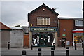
Tidenham Royal British Legion Club, Sedbury
The club is the single-storey building set back a few metres from the east side of Grahamstown Road, Sedbury.
Image: © Jaggery
Taken: 17 Sep 2010
0.03 miles
2
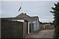
Some Sedbury prisoner of war camp huts
Image: © Nick Mutton 01329 000000
Taken: 29 Jun 2010
0.06 miles
4
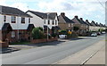
Grahamstown Road, Sedbury
Houses on the east side of the road, viewed from alongside the Evangelical Church. http://www.geograph.org.uk/photo/1940920
Image: © Jaggery
Taken: 17 Sep 2010
0.07 miles
5
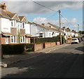
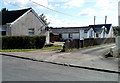
Southern end of Grahamstown Road, Sedbury
Grahamstown Road runs for about 350 metres from Beachley Road to Sedbury Business Park.
These houses are on the western side of the road, viewed from near the corner of Beachley Road.
Image: © Jaggery
Taken: 17 Sep 2010
0.07 miles
6
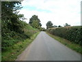
Sedbury Lane heads away from Beachley Road
A neat, trimmed hedge on the right contrasts with the other side of Sedbury Lane.
The photographer is about 100 metres NNE of Beachley Road.
Image: © Jaggery
Taken: 17 Sep 2010
0.07 miles
7
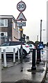
Warning sign - humps for 50 yds, Tylers Way, Sedbury, Gloucestershire
The sign faces Beachley Road.
Image: © Jaggery
Taken: 19 Nov 2023
0.07 miles
8
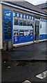
Mark's Mobile Butchers, Sedbury, Gloucestershire
Beachley Road butchers viewed in November 2023.
The shop was Sedbury Butchers in 2010. https://www.geograph.org.uk/photo/2076859
Image: © Jaggery
Taken: 19 Nov 2023
0.07 miles
9
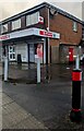
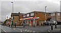
SPAR, Beachley Road, Sedbury, Gloucestershire
In November 2023 a red and white POST OFFICE sign is on the wall of
the convenience store on the corner of Tylers Way. A Queen Elizabeth II
pillarbox is on the right.
Image: © Jaggery
Taken: 19 Nov 2023
0.07 miles