IMAGES TAKEN NEAR TO
Llanvair Discoed, CHEPSTOW, NP16 6TA
Introduction
This page details the photographs taken nearby to NP16 6TA by members of the Geograph project.
The Geograph project started in 2005 with the aim of publishing, organising and preserving representative images for every square kilometre of Great Britain, Ireland and the Isle of Man.

There are currently over 7.5m images from over14,400 individuals and you can help contribute to the project by visiting https://www.geograph.org.uk
Image Map
Images are licensed for reuse under creativecommons.org/licenses/by-sa/2.0
Notes
- Clicking on the map will re-center to the selected point.
- The higher the marker number, the further away the image location is from the centre of the postcode.
Image Listing (8 Images Found)
Images are licensed for reuse under creativecommons.org/licenses/by-sa/2.0
Image
Details
Distance
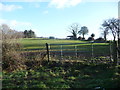
1
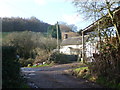
Cil-voynog farm
Traditional small upland farm cottage.
Image: © Jeremy Bolwell
Taken: 27 Jan 2013
0.02 miles
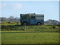
2
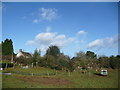
Approaching Cil-voynog farm
An old classic Landy lies abandoned in the pasture here.
Image: © Jeremy Bolwell
Taken: 27 Jan 2013
0.03 miles
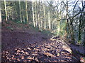
3
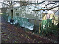
Old caravan on the wood edge
Long abandoned, floor gone, awaiting Nature's slow approach and re-absorbtion.
Image: © Jeremy Bolwell
Taken: 27 Jan 2013
0.07 miles
4
Old Landy and horsebox
I wonder how long these items have been here?
Image: © Jeremy Bolwell
Taken: 27 Jan 2013
0.21 miles
5
Hilltop fields
An old Landy sits up here. near some sort of shed.
Image: © Jeremy Bolwell
Taken: 27 Jan 2013
0.22 miles
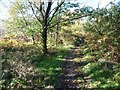
6
Track in woodland
Steep, muddy, slippery and much trodden by cattle; just my sort of route.
Image: © Jeremy Bolwell
Taken: 27 Jan 2013
0.22 miles
7
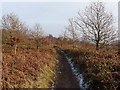
Path on Gray Hill, Wentwood
A narrow path along the ridgeline passing through young oak woods, scrub, heath and briars.
Image: © Jeremy Bolwell
Taken: 27 Oct 2012
0.22 miles