IMAGES TAKEN NEAR TO
Barbadoes, Tintern, CHEPSTOW, NP16 6ST
Introduction
This page details the photographs taken nearby to NP16 6ST by members of the Geograph project.
The Geograph project started in 2005 with the aim of publishing, organising and preserving representative images for every square kilometre of Great Britain, Ireland and the Isle of Man.

There are currently over 7.5m images from over14,400 individuals and you can help contribute to the project by visiting https://www.geograph.org.uk
Image Map
Images are licensed for reuse under creativecommons.org/licenses/by-sa/2.0
Notes
- Clicking on the map will re-center to the selected point.
- The higher the marker number, the further away the image location is from the centre of the postcode.
Image Listing (2 Images Found)
Images are licensed for reuse under creativecommons.org/licenses/by-sa/2.0
Image
Details
Distance
1
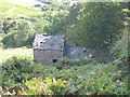
Derelict barn near Tintern
At the time this picture was taken, the barn was about to be auctioned with planning permission for conversion to a two-bedroom dwelling.
Image: © John Thorn
Taken: 15 Sep 2004
0.08 miles
2
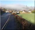
Hillside fog, Tintern
Viewed along the A466 on a January morning. The fog cleared soon after this view was taken at 10.36am
Image: © Jaggery
Taken: 19 Jan 2014
0.12 miles