IMAGES TAKEN NEAR TO
Trelleck Road, CHEPSTOW, NP16 6SN
Introduction
This page details the photographs taken nearby to Trelleck Road, NP16 6SN by members of the Geograph project.
The Geograph project started in 2005 with the aim of publishing, organising and preserving representative images for every square kilometre of Great Britain, Ireland and the Isle of Man.

There are currently over 7.5m images from over14,400 individuals and you can help contribute to the project by visiting https://www.geograph.org.uk
Image Map
Images are licensed for reuse under creativecommons.org/licenses/by-sa/2.0
Notes
- Clicking on the map will re-center to the selected point.
- The higher the marker number, the further away the image location is from the centre of the postcode.
Image Listing (3 Images Found)
Images are licensed for reuse under creativecommons.org/licenses/by-sa/2.0
Image
Details
Distance
1
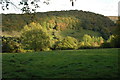
View to Coed Beddick
View across the valley to Coed Beddick above Tintern.
Image: © Philip Halling
Taken: 24 Oct 2010
0.06 miles
2
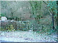
Path into Coed Beddick
Leading east from the Tintern to Trellech Road.
Image: © Jonathan Billinger
Taken: 17 Dec 2010
0.08 miles
3
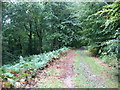
The Wye Valley Walk in Coed Beddick
Descending towards Brockweir.
Image: © David Purchase
Taken: 21 Sep 2015
0.24 miles