IMAGES TAKEN NEAR TO
Tintern, CHEPSTOW, NP16 6SJ
Introduction
This page details the photographs taken nearby to NP16 6SJ by members of the Geograph project.
The Geograph project started in 2005 with the aim of publishing, organising and preserving representative images for every square kilometre of Great Britain, Ireland and the Isle of Man.

There are currently over 7.5m images from over14,400 individuals and you can help contribute to the project by visiting https://www.geograph.org.uk
Image Map
Images are licensed for reuse under creativecommons.org/licenses/by-sa/2.0
Notes
- Clicking on the map will re-center to the selected point.
- The higher the marker number, the further away the image location is from the centre of the postcode.
Image Listing (142 Images Found)
Images are licensed for reuse under creativecommons.org/licenses/by-sa/2.0
Image
Details
Distance
1
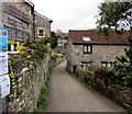
Side road descending towards the River Wye, Tintern
From the A466 the side road descends towards the north bank of the River Wye.
This way to St Michael's Church, http://www.geograph.org.uk/photo/5317403 the Wye Valley Walk and the Tewdrig Trail.
Image: © Jaggery
Taken: 17 Mar 2017
0.01 miles
2
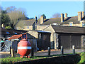
Mine near the Church
Not the sort of mine more usually associated with this region. This is one of the old exploding variety that you find at the seaside collecting donations for maritime charities.
I'm not sure if it's still in use in this rather unlikely location.
Image: © Des Blenkinsopp
Taken: 30 Dec 2019
0.01 miles
3
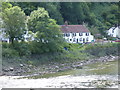
Tintern: View upstream from the Wire Bridge
With a long-focus lens
Image: © Dr Neil Clifton
Taken: 3 Jul 2015
0.01 miles
4
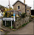
Wooden signpost on a Tintern corner, 2 miles from Catbrook
The signpost is on the corner of the A466 and a side road. Left for Tintern Pentecostal Church or right along the side road for St Michael's Church http://www.geograph.org.uk/photo/5317347 the Wye Valley Walk and the Tewdrig Trail.
Image: © Jaggery
Taken: 17 Mar 2017
0.01 miles
5
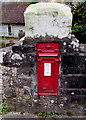
King George V postbox in a Tintern wall
Located here, http://www.geograph.org.uk/photo/5317549 on the south side of the A466, near the Trelleck Road junction.
The GR on the box is short for Georgius Rex, Latin for King George,
in this case King George V who reigned from May 1910-January 1936.
Image: © Jaggery
Taken: 17 Mar 2017
0.02 miles
6
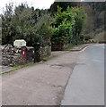
Postbox in a Tintern wall
The King George V box http://www.geograph.org.uk/photo/5317546 is on the south side of the A466, near the Trelleck Road junction.
Image: © Jaggery
Taken: 17 Mar 2017
0.02 miles
7
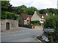
Tintern - the Catbrook road junction
The Wye Valley Hotel is partly visible on the corner
Image: © Roy Parkhouse
Taken: 14 Jul 2007
0.02 miles
8
Bend in the A466, Tintern
The Trelleck Road junction is on the right. Ahead for the ruins of Tintern Abbey. https://www.geograph.org.uk/photo/5501499
Image: © Jaggery
Taken: 29 Jun 2019
0.02 miles
9
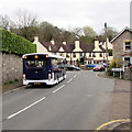
Monmouth bus on the A466 in Tintern
The Phil Anslow Coaches bus is on bus route 69 from Chepstow to Monmouth.
The Wye Valley Hotel http://www.geograph.org.uk/photo/5317484 is in the background.
Image: © Jaggery
Taken: 17 Mar 2017
0.02 miles
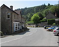
10
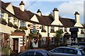
The Wye Valley Hotel, Tintern
A splendid 1930's roadside inn.
Image: © Jonathan Billinger
Taken: 28 Dec 2006
0.02 miles