IMAGES TAKEN NEAR TO
Upper Leytons, CHEPSTOW, NP16 6SD
Introduction
This page details the photographs taken nearby to Upper Leytons, NP16 6SD by members of the Geograph project.
The Geograph project started in 2005 with the aim of publishing, organising and preserving representative images for every square kilometre of Great Britain, Ireland and the Isle of Man.

There are currently over 7.5m images from over14,400 individuals and you can help contribute to the project by visiting https://www.geograph.org.uk
Image Map
Images are licensed for reuse under creativecommons.org/licenses/by-sa/2.0
Notes
- Clicking on the map will re-center to the selected point.
- The higher the marker number, the further away the image location is from the centre of the postcode.
Image Listing (571 Images Found)
Images are licensed for reuse under creativecommons.org/licenses/by-sa/2.0
Image
Details
Distance
2
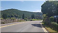
The A466 leaving Tintern
The main feature on the south side of the village is the ruined abbey.
Image: © Bill Boaden
Taken: 3 Aug 2018
0.03 miles
3
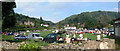
Car Boot Sale at the Anchor Field, Tintern
This is normally a playing field. Tintern Abbey is behind the photographer; the Anchor Inn is to the right.
Image: © Roy Parkhouse
Taken: 15 Jul 2006
0.03 miles
4
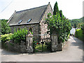
Tintern - Converted Church or Chapel?
This house is alongside the footpath between Tintern Abbey and Abbey Mill. The clothes line in the garden does suggest that it is no longer a church or chapel.
Image: © Roy Parkhouse
Taken: 1 Jul 2006
0.03 miles
5
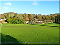
Football pitch, Tintern
The pitch is on a narrow strip of flat land between the River Wye and steep ground bordering the A466.
Image: © Jaggery
Taken: 27 Nov 2011
0.03 miles
6
The Piano Centre, Tintern
Located alongside the A466 in The Shop, Abbey Lodge. The business sells new, used and reconditioned pianos, buys pianos and arranges piano hire and removals. The business specialises in grand pianos for country houses.
Image: © Jaggery
Taken: 14 Aug 2014
0.03 miles
7
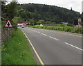
Warning sign - minor crossroads ahead, Tintern
The sign faces the A466 on the approach to the crossroads with Forge Road and an unnamed side road.
Image: © Jaggery
Taken: 16 Aug 2017
0.03 miles
8
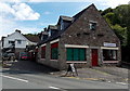
Small coffee house, Tintern
Closed on this dull, February day.
Image: © Pauline E
Taken: 24 Feb 2008
0.04 miles
9
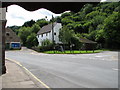
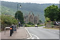
Tintern - the Raglan road junction
Looking towards Chepstow. The road on the right leads up to Tintern Cross (and eventually to Raglan). The narrow road just left of centre runs behind houses and the Abbey Hotel, degenerating into a rocky track - it's part of the Wye Valley Walk. The Royal George Hotel stands on the corner to the right of this photograph.
Image: © Roy Parkhouse
Taken: 28 Jul 2007
0.04 miles
10
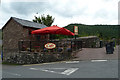
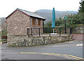
Tintern - the "Italian Garden" cafe
A recent addition
Image: © Roy Parkhouse
Taken: 29 Jul 2011
0.04 miles