IMAGES TAKEN NEAR TO
Usk Road, CHEPSTOW, NP16 6RY
Introduction
This page details the photographs taken nearby to Usk Road, NP16 6RY by members of the Geograph project.
The Geograph project started in 2005 with the aim of publishing, organising and preserving representative images for every square kilometre of Great Britain, Ireland and the Isle of Man.

There are currently over 7.5m images from over14,400 individuals and you can help contribute to the project by visiting https://www.geograph.org.uk
Image Map
Images are licensed for reuse under creativecommons.org/licenses/by-sa/2.0
Notes
- Clicking on the map will re-center to the selected point.
- The higher the marker number, the further away the image location is from the centre of the postcode.
Image Listing (7 Images Found)
Images are licensed for reuse under creativecommons.org/licenses/by-sa/2.0
Image
Details
Distance
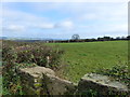
2
Public footpath across field
Image: © Nick Mutton 01329 000000
Taken: 19 Jul 2010
0.18 miles
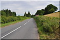
4
WNW along the B4235 in rural Monmouthshire
The B4235 Usk Road viewed from the edge of Llwyn-y-Celyn Wood.
Image: © Jaggery
Taken: 6 Mar 2022
0.19 miles
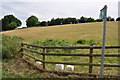
5
Stone stile into a field, near Shirenewton
This stile gives access to the footpath opposite Image
Image: © Ruth Sharville
Taken: 9 Nov 2014
0.21 miles
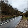
6
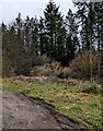
Edge of Llwyn-y-Celyn Wood in rural Monmouthshire
Viewed from the B4235 Usk Road in March 2022.
Image: © Jaggery
Taken: 6 Mar 2022
0.23 miles
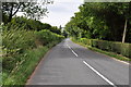
7
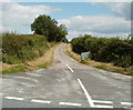
Road to the B4235 near Shirenewton
Viewed from the Earlswood to Shirenewton road. The B4235 is nearly 500 metres ahead.
Image: © Jaggery
Taken: 14 Jul 2011
0.25 miles