IMAGES TAKEN NEAR TO
Mynyddbach, Shirenewton, CHEPSTOW, NP16 6RR
Introduction
This page details the photographs taken nearby to NP16 6RR by members of the Geograph project.
The Geograph project started in 2005 with the aim of publishing, organising and preserving representative images for every square kilometre of Great Britain, Ireland and the Isle of Man.

There are currently over 7.5m images from over14,400 individuals and you can help contribute to the project by visiting https://www.geograph.org.uk
Image Map
Images are licensed for reuse under creativecommons.org/licenses/by-sa/2.0
Notes
- Clicking on the map will re-center to the selected point.
- The higher the marker number, the further away the image location is from the centre of the postcode.
Image Listing (65 Images Found)
Images are licensed for reuse under creativecommons.org/licenses/by-sa/2.0
Image
Details
Distance
1
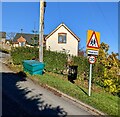
Warning sign - Playground, Old School Hill, Mynydd-bach, Monmouthshire
Above a 30mph speed limit sign.
Image: © Jaggery
Taken: 28 Nov 2021
0.04 miles
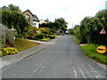
2
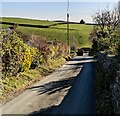
Down Old School Hill, Mynydd-bach, Monmouthshire
Old School Hill descends towards Spout Hill.
Image: © Jaggery
Taken: 28 Nov 2021
0.04 miles
3
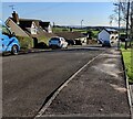
Blethyn Close, Mynydd-bach, Monmouthshire
Looking to the SE along Blethyn Close in November 2021.
Image: © Jaggery
Taken: 28 Nov 2021
0.04 miles
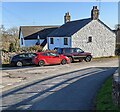
4
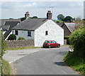
Red mini and whitewashed house, Mynydd-bach
A view of the top (northern) end of Old School Hill. The house was formerly the village schoolhouse.
Image: © Jaggery
Taken: 14 Jul 2011
0.05 miles
5
Whitewashed house, Mynydd-bach, Monmouthshire
At the top of Old School Hill.
Image: © Jaggery
Taken: 28 Nov 2021
0.05 miles
6
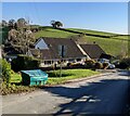
Dormer bungalows, Mynydd-bach, Monmouthshire
Viewed across Old School Hill.
Image: © Jaggery
Taken: 28 Nov 2021
0.06 miles
7
Up Old School Hill, Mynydd-bach
Old School Hill climbs away from the Spout Hill junction (50 metres behind the camera).
Image: © Jaggery
Taken: 14 Jul 2011
0.06 miles
8
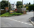
Northern end of The Laurels, Mynydd-bach
Occupying the corner are a road sign, a yellow box for road salt
or road grit, a community noticeboard and a red postbox on a stand.
Image: © Jaggery
Taken: 14 Jul 2011
0.06 miles
9
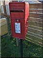
Queen Elizabeth II postbox, Mynydd-bach, Monmouthshire
Located here. https://www.geograph.org.uk/photo/3185023
Image: © Jaggery
Taken: 28 Nov 2021
0.07 miles
10

Bilingual name sign, Mynydd-bach, Monmouthshire
The sign located here https://www.geograph.org.uk/photo/3184868 shows that Blethyn Close is Clos Blethyn in Welsh.
Image: © Jaggery
Taken: 28 Nov 2021
0.08 miles