IMAGES TAKEN NEAR TO
Earlswood, CHEPSTOW, NP16 6RD
Introduction
This page details the photographs taken nearby to NP16 6RD by members of the Geograph project.
The Geograph project started in 2005 with the aim of publishing, organising and preserving representative images for every square kilometre of Great Britain, Ireland and the Isle of Man.

There are currently over 7.5m images from over14,400 individuals and you can help contribute to the project by visiting https://www.geograph.org.uk
Image Map
Images are licensed for reuse under creativecommons.org/licenses/by-sa/2.0
Notes
- Clicking on the map will re-center to the selected point.
- The higher the marker number, the further away the image location is from the centre of the postcode.
Image Listing (13 Images Found)
Images are licensed for reuse under creativecommons.org/licenses/by-sa/2.0
Image
Details
Distance
1
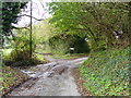
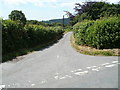
Road and path junction by Oxpool Farm, near Earlswood
Image: © Ruth Sharville
Taken: 9 Nov 2014
0.05 miles
2
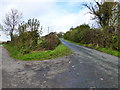
One of many road junctions near Oxpool Farm, Earlswood
Image: © Ruth Sharville
Taken: 9 Nov 2014
0.06 miles
4
SSE along a minor road, Earlswood
In rural Monmouthshire.
Image: © Jaggery
Taken: 17 Jul 2022
0.18 miles
5
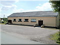
Earlswood and Newchurch West War Memorial Hall
Located in the small rural community of Earlswood, near Shirenewton. The hall was built from public donations as a memorial to local residents who were killed in the Second World War.
The main hall can accommodate up to about 150 people. There is also a small meeting room.
Image: © Jaggery
Taken: 14 Jul 2011
0.19 miles
6

Towards a field and houses, Earlswood, Monmouthshire
Looking south from near Earlswood & Newchurch West Memorial Hall. https://www.geograph.org.uk/photo/7230588
Image: © Jaggery
Taken: 17 Jul 2022
0.23 miles
7
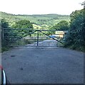
Gate across a farm access road, Earlswood
In rural Monmouthshire.
Image: © Jaggery
Taken: 17 Jul 2022
0.23 miles
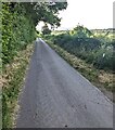
8
Country lane, Earlswood
Earlswood is a small rural community in Monmouthshire, to the NW of Shirenewton.
The houses are mostly distributed across a wide area. This lane leads to two houses about 200 metres apart, The Grove Cottage and Panderry.
Image: © Jaggery
Taken: 14 Jul 2011
0.24 miles
9
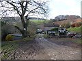
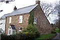
Cottages above the Castrogi Brook
A smallholding or cottage above this beautiful, secluded rural valley.
Image: © Jeremy Bolwell
Taken: 27 Jan 2013
0.24 miles
10
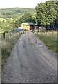
Chapel Farm access road, Earlswood
Viewed from this https://www.geograph.org.uk/photo/7230941 gate in rural Monmouthshire.
Image: © Jaggery
Taken: 17 Jul 2022
0.24 miles