IMAGES TAKEN NEAR TO
Llanishen, CHEPSTOW, NP16 6QD
Introduction
This page details the photographs taken nearby to NP16 6QD by members of the Geograph project.
The Geograph project started in 2005 with the aim of publishing, organising and preserving representative images for every square kilometre of Great Britain, Ireland and the Isle of Man.

There are currently over 7.5m images from over14,400 individuals and you can help contribute to the project by visiting https://www.geograph.org.uk
Image Map
Images are licensed for reuse under creativecommons.org/licenses/by-sa/2.0
Notes
- Clicking on the map will re-center to the selected point.
- The higher the marker number, the further away the image location is from the centre of the postcode.
Image Listing (11 Images Found)
Images are licensed for reuse under creativecommons.org/licenses/by-sa/2.0
Image
Details
Distance
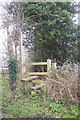
1
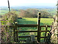
Stile to diverging footpaths, near Llanishen
Image: © Ruth Sharville
Taken: 30 Nov 2014
0.03 miles
2
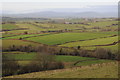
View to the Black Mountains
View to the Black Mountains from a footpath above Duke's Farm to the west of Llanishen. Among the Black Mountains the distinctive shape of Sugar loaf can be seen along with Skirrid to the right.
Image: © Philip Halling
Taken: 10 Dec 2011
0.13 miles
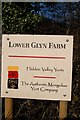
6
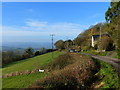
The road out of Llanishen, with views
Image: © Ruth Sharville
Taken: 30 Nov 2014
0.19 miles
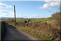
7
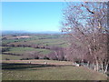
Monmouthshire countryside
This view is typical of the landscape lying between the Wye and the Usk.
Image: © Jonathan Billinger
Taken: 14 Feb 2007
0.20 miles
8
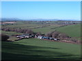
Llanvair panorama
The viewpoint not only shows well the farm and its surrounding pasture, but a clear skyline of the Black Mountains in the distance. Blorenge, Sugarloaf,The Skirrid, and Hay Bluff are ranged from left to right.
Image: © Jonathan Billinger
Taken: 14 Feb 2007
0.23 miles
9
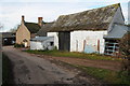
Barn and farmhouse, Llanfair
Traditional barn on the roadside at Llanfair, near Llanishen.
Image: © Philip Halling
Taken: 10 Dec 2011
0.24 miles
10
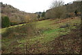
Penarth Brook valley
Vakkey through which Penarth Brook flows, near Llanishen.
Image: © Philip Halling
Taken: 10 Dec 2011
0.25 miles