IMAGES TAKEN NEAR TO
Devauden, CHEPSTOW, NP16 6NR
Introduction
This page details the photographs taken nearby to NP16 6NR by members of the Geograph project.
The Geograph project started in 2005 with the aim of publishing, organising and preserving representative images for every square kilometre of Great Britain, Ireland and the Isle of Man.

There are currently over 7.5m images from over14,400 individuals and you can help contribute to the project by visiting https://www.geograph.org.uk
Image Map
Images are licensed for reuse under creativecommons.org/licenses/by-sa/2.0
Notes
- Clicking on the map will re-center to the selected point.
- The higher the marker number, the further away the image location is from the centre of the postcode.
Image Listing (7 Images Found)
Images are licensed for reuse under creativecommons.org/licenses/by-sa/2.0
Image
Details
Distance
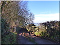
1
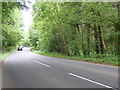
The A4293 heading south towards Devauden
Image: © Eirian Evans
Taken: 26 May 2019
0.07 miles
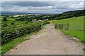
2
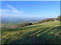
View from track junction at Tredean
Mist is lying in the valleys on this late November day.
Image: © Ruth Sharville
Taken: 30 Nov 2014
0.08 miles
3
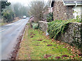
Milestone at New Inn - Chepstow 6 miles
This milestone, hard against the wall in the centre of the photograph, reads "To Chepstow 6 Miles". The view is towards Monmouth.
Image: © Roy Parkhouse
Taken: 1 Feb 2006
0.11 miles
4
Sugar Loaf
Sugar Loaf from a distance.
Image: © Richard Smith
Taken: 28 Aug 2008
0.14 miles
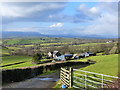
6
Entrance and drive to Tredean Farm
Entrance and drive to Tredean Farm near New Inn. Beyond is a beautiful view of Monmouthshire with the Black Mountains on the horizon directly above the get. To the left is the Usk valley with Blorenge on the left.
Image: © Philip Halling
Taken: 15 Jun 2018
0.20 miles
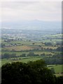
7
Tredean Farm
The peaks of Blorenge, Sugar Loaf and Ysgyryd Fawr can be seen in the far distance.
Image: © Ruth Sharville
Taken: 16 Jan 2015
0.21 miles