IMAGES TAKEN NEAR TO
Court House Road, CHEPSTOW, NP16 6LW
Introduction
This page details the photographs taken nearby to Court House Road, NP16 6LW by members of the Geograph project.
The Geograph project started in 2005 with the aim of publishing, organising and preserving representative images for every square kilometre of Great Britain, Ireland and the Isle of Man.

There are currently over 7.5m images from over14,400 individuals and you can help contribute to the project by visiting https://www.geograph.org.uk
Image Map
Images are licensed for reuse under creativecommons.org/licenses/by-sa/2.0
Notes
- Clicking on the map will re-center to the selected point.
- The higher the marker number, the further away the image location is from the centre of the postcode.
Image Listing (129 Images Found)
Images are licensed for reuse under creativecommons.org/licenses/by-sa/2.0
Image
Details
Distance
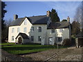
1
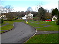
Court House Road houses, Llanvair Discoed
Houses in a spacious cul-de-sac in a small village in Monmouthshire.
Image: © Jaggery
Taken: 15 Feb 2012
0.03 miles
2
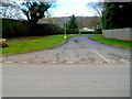
Court House Road, Llanvair Discoed
The southern end of a cul-de-sac in a small village in Monmouthshire.
Image: © Jaggery
Taken: 15 Feb 2012
0.04 miles
3
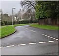
North along Court House Road, Llanvair Discoed
Viewed across the main road into the Monmouthshire village.
Image: © Jaggery
Taken: 26 Dec 2021
0.04 miles
4
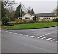
Bungalow, Court House Road, Llanvair Discoed
Derived from a Hindi word meaning 'in the style of Bengal', bungalow was originally used in English for a lightly-built house, with a veranda and one storey. In current UK usage it is a convenient word for any one-storey dwelling.
Image: © Jaggery
Taken: 26 Dec 2021
0.05 miles
5
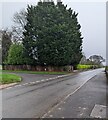
Evergreen corner of Llanvair Discoed
Viewed on Boxing Day December 26th 2021.
Image: © Jaggery
Taken: 26 Dec 2021
0.06 miles
6
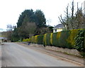
Variegated hedge in Llanvair Discoed
The alternating patches of green and yellow are distinct enough to be seen on satellite images.
Image: © Jaggery
Taken: 15 Feb 2012
0.07 miles
8
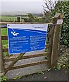
Blue notice on a wooden gate, Llanvair Discoed
The Caerwent Community Council notice is at the entrance to this https://www.geograph.org.uk/photo/7054234 play area in December 2021 during the Coronavirus (COVID-19) pandemic. Extensive guidelines to prevent the spread of COVID-19 are shown in English and Welsh. A plaque on the post on the right shows PLAY EQUIPMENT DONATED BY LLANVAIR HALL VILLAGE FUND.
Image: © Jaggery
Taken: 26 Dec 2021
0.07 miles
9
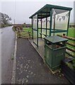
Bunting in a Llanvair Discoed bus shelter
Viewed on Boxing Day December 26th 2021.
Image: © Jaggery
Taken: 26 Dec 2021
0.07 miles
10
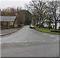
East along an unnamed road, Llanvair Discoed
Ahead for Court House Road. https://www.geograph.org.uk/photo/7054204
Image: © Jaggery
Taken: 26 Dec 2021
0.07 miles