IMAGES TAKEN NEAR TO
Baileys Hay, CHEPSTOW, NP16 6JP
Introduction
This page details the photographs taken nearby to Baileys Hay, NP16 6JP by members of the Geograph project.
The Geograph project started in 2005 with the aim of publishing, organising and preserving representative images for every square kilometre of Great Britain, Ireland and the Isle of Man.

There are currently over 7.5m images from over14,400 individuals and you can help contribute to the project by visiting https://www.geograph.org.uk
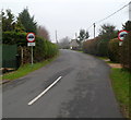
Image Map
Images are licensed for reuse under creativecommons.org/licenses/by-sa/2.0
Notes
- Clicking on the map will re-center to the selected point.
- The higher the marker number, the further away the image location is from the centre of the postcode.
Image Listing (60 Images Found)
Images are licensed for reuse under creativecommons.org/licenses/by-sa/2.0
Image
Details
Distance
1
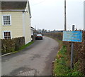
Bailey's Hay, Mathern
The side road ahead, Bailey's Hay, is unsuitable for heavy goods vehicles.
The Old Court House http://www.geograph.org.uk/photo/2785224 is on the left.
Image: © Jaggery
Taken: 29 Jan 2012
0.03 miles
2
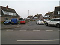
St Tewdrics Place, Mathern
A cul-de-sac on the south side of the main road through the village.
Image: © Jaggery
Taken: 29 Jan 2012
0.04 miles
3
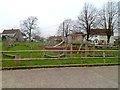
Mathern Jubilee Park
The park, adjacent to the village hall, http://www.geograph.org.uk/photo/3130043 opened in 2002, the year of Queen Elizabeth II's Golden Jubilee.
Image: © Jaggery
Taken: 29 Jan 2012
0.05 miles
4
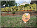
Bee Friendly on Bailey's Hay
A sliver of grass along the row of houses is planted and maintained for the benefit of the pollinators.
Image: © Neil Owen
Taken: 26 Aug 2022
0.06 miles
6
Northern boundary of Mathern
The unnamed connecting road from the A48 reaches the Monmouthshire village of Mathern.
This part of the village is known as Newton Green.
Image: © Jaggery
Taken: 29 Jan 2012
0.06 miles
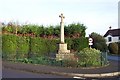
7
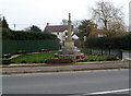
Mathern War Memorial
Located at the northern edge of the village, at the southern end of Chapel Lane.
The Memorial is a cross on an octagonal base, atop a three-step octagonal plinth.
Image: © Jaggery
Taken: 29 Jan 2012
0.06 miles
8
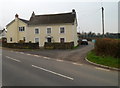
Old Court House, Mathern
Now a private residence, the old court house is at the northern edge of the village, opposite Chapel Lane and the War Memorial. http://www.geograph.org.uk/photo/2785223
Image: © Jaggery
Taken: 29 Jan 2012
0.06 miles
9
Weight limit along Chapel Lane, Mathern
A sign at the southern end of Chapel Lane imposes a 7.5 tonne vehicle weight limit, except for access.
Image: © Jaggery
Taken: 29 Jan 2012
0.06 miles
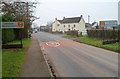
10
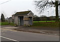
A Mathern bus shelter
Located alongside the main road through the village, between St Tewdrics Place and Mathern Crescent. Flower boxes, empty in this winter view, will probably have a pleasing floral display later in the year.
Image: © Jaggery
Taken: 29 Jan 2012
0.06 miles