IMAGES TAKEN NEAR TO
St. Arvans, CHEPSTOW, NP16 6HH
Introduction
This page details the photographs taken nearby to NP16 6HH by members of the Geograph project.
The Geograph project started in 2005 with the aim of publishing, organising and preserving representative images for every square kilometre of Great Britain, Ireland and the Isle of Man.

There are currently over 7.5m images from over14,400 individuals and you can help contribute to the project by visiting https://www.geograph.org.uk
Image Map
Images are licensed for reuse under creativecommons.org/licenses/by-sa/2.0
Notes
- Clicking on the map will re-center to the selected point.
- The higher the marker number, the further away the image location is from the centre of the postcode.
Image Listing (9 Images Found)
Images are licensed for reuse under creativecommons.org/licenses/by-sa/2.0
Image
Details
Distance
1
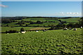
View to the east from Gaer Hill
Gaer Hill provides an excellent viewpoint, pictured here is the view to the east over the Wye Valley to Gloucestershire and the descend line of the Cotswold Hills.
Image: © Philip Halling
Taken: 24 Oct 2010
0.05 miles
2
View over the Wye Valley
View over the Wye Valley towards the Forest of Dean from footpath which ascents Gaer Hill from the east.
Image: © Philip Halling
Taken: 24 Oct 2010
0.08 miles
3
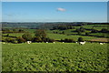
View to St Briavels
View across the Wye Valley from Wales to England with St Briavels visible above the valley. Beyond on the horizon is the Forest of Dean.
Image: © Philip Halling
Taken: 24 Oct 2010
0.08 miles
4
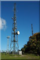
Masts on Gaer Hill
Despite its modest height of 260m Gaer Hill is an excellent viewpoint and also an ideal location for telecommunication masts.
Image: © Philip Halling
Taken: 24 Oct 2010
0.15 miles
5
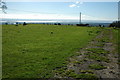
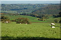
View over the Bristol Channel
The top of Gaer Hill is only 260m above sea level, however, it is a wonderful viewpoint, this is the view to the south of the Severn estuary and Bristol Channel. To the left the River Wye is visible just before its confluence, above it is the old Severn Bridge with the Second Severn Crossing in the centre. Beyond are the Somerset Hills.
Image: © Philip Halling
Taken: 24 Oct 2010
0.17 miles
6
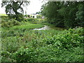
Pool near Porthcasseg
Interesting pool or old pond below a property here.
Image: © Jeremy Bolwell
Taken: 26 Aug 2012
0.18 miles
7
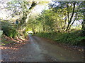
Lane to Penterry Farm, Penterry, near St Arvans
Image: © Ruth Sharville
Taken: 20 Nov 2022
0.19 miles
9
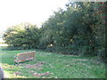
Penterry plague burial pit
The information board outside Penterry church has this to say : "The church field was purchased in 1996 and is owned and managed on trust for the benefit of St Mary's. It is the site of the medieval village of Penterry, the population of which is believed to have been decimated by plague in the mid 14th century. A burial pit has been identified in a hazel grove on the edge of the field and aerial photographs have shown the outlines of buildings". The hazel grove mentioned is shown here, to the right of the seat. Image
Image: © Roy Parkhouse
Taken: 14 Oct 2009
0.25 miles