IMAGES TAKEN NEAR TO
Piercefield Terrace, CHEPSTOW, NP16 6EW
Introduction
This page details the photographs taken nearby to Piercefield Terrace, NP16 6EW by members of the Geograph project.
The Geograph project started in 2005 with the aim of publishing, organising and preserving representative images for every square kilometre of Great Britain, Ireland and the Isle of Man.

There are currently over 7.5m images from over14,400 individuals and you can help contribute to the project by visiting https://www.geograph.org.uk
Image Map
Images are licensed for reuse under creativecommons.org/licenses/by-sa/2.0
Notes
- Clicking on the map will re-center to the selected point.
- The higher the marker number, the further away the image location is from the centre of the postcode.
Image Listing (104 Images Found)
Images are licensed for reuse under creativecommons.org/licenses/by-sa/2.0
Image
Details
Distance
1
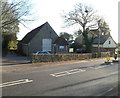
St Arvans village hall
St Arvans Memorial Hall was built in 1924 in memory of those who died in the First World War.
It is located alongside the A466 on the eastern side of the village.
Image: © Jaggery
Taken: 27 Nov 2011
0.01 miles
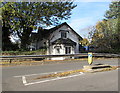
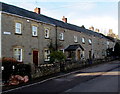
2
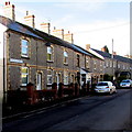
Piercefield Terrace, St Arvans
One of several named rows of houses in Devauden Road.
Image: © Jaggery
Taken: 11 Nov 2016
0.01 miles
3
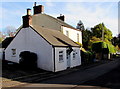
The Nook, Devauden Road, St Arvans
Single-storey house near the corner of Forge Gardens.
Image: © Jaggery
Taken: 11 Nov 2016
0.01 miles
5
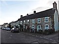
Turnpike Cottage, St Arvans
Built as a toll cottage as part of the new Chepstow to Monmouth turnpike road which opened in 1829.
The turnpike trusts were wound up in 1873 when responsibility for the road passed to the Chepstow Highways Board and later to Monmouthshire County Council. Turnpike Cottage was grade II listed in 2001.
Image: © Jaggery
Taken: 11 Nov 2016
0.03 miles
6
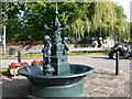
Victorian Drinking Fountain, St Arvans
In the 1890's Monmouthshire County Council decided to install drinking fountains throughout the county. The local residents of St Arvan raised an additional £30 to purchase this special fountain, which was manufactured in Glasgow. It was renovated for the millennium.
Image: © Eirian Evans
Taken: 25 Sep 2010
0.04 miles
7
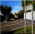
Distances from St Arvans
On the corner of the A466, the sign pointing towards Devauden Road shows Devauden 3 (miles), Trellech 8.
Image: © Jaggery
Taken: 11 Nov 2016
0.04 miles
8
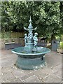
Victorian fountain
In the early 1890’s it was decided to install drinking fountains throughout the county of Monmouthshire in Wales. As local denizens of St. Arvans held the beauty of the area in high regard, they raised funds to purchase a more elaborate fountain.
A marker on the site acknowledges Marsden Lloyd, a member of the team who initiated the renovation of the fountain for the new millennium. Fundraising and additional grants enable the restoration, and it is now a true working example of a Victorian fountain.
It was manufactured by George Smith & Co. (a stamp on the central column states The Sun Foundry of Glasgow), and assembled in the Iron Stores in Chepstow . It was erected in 1893 on the corner of Fordwich Close and Devauden Road, and designated a grade II listed building on 18 July 1997.
Image: © Alan Hughes
Taken: 15 Jul 2020
0.04 miles
9
The Row, St Arvans
One of several named rows of houses in Devauden Road.
Image: © Jaggery
Taken: 11 Nov 2016
0.04 miles
10

Forge Gardens, St Arvans
Cul-de-sac viewed across Devauden Road.
Image: © Jaggery
Taken: 11 Nov 2016
0.04 miles