IMAGES TAKEN NEAR TO
Newchurch, CHEPSTOW, NP16 6DA
Introduction
This page details the photographs taken nearby to NP16 6DA by members of the Geograph project.
The Geograph project started in 2005 with the aim of publishing, organising and preserving representative images for every square kilometre of Great Britain, Ireland and the Isle of Man.

There are currently over 7.5m images from over14,400 individuals and you can help contribute to the project by visiting https://www.geograph.org.uk
Image Map
Images are licensed for reuse under creativecommons.org/licenses/by-sa/2.0
Notes
- Clicking on the map will re-center to the selected point.
- The higher the marker number, the further away the image location is from the centre of the postcode.
Image Listing (7 Images Found)
Images are licensed for reuse under creativecommons.org/licenses/by-sa/2.0
Image
Details
Distance
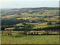
2
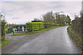
Field-edge view from Newchurch Triangulation Pillar
Looking northward.
Image: © Peter Wood
Taken: 17 Oct 2016
0.05 miles
3
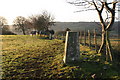
Newchurch trig
Looking S from position
Image: © Iain Macaulay
Taken: 19 Dec 2005
0.12 miles
4
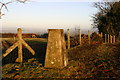
Newchurch trig
Looking NNW from position
Image: © Iain Macaulay
Taken: 19 Dec 2005
0.12 miles
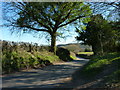
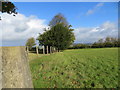
6
Field, fence and view near Hillside, Newchurch
Image: © Ruth Sharville
Taken: 3 Jul 2010
0.24 miles
7
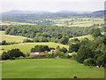
Looking North over Kilgwrrwg House
Looking North toward Monmouth/Pandy area.
Image: © Richard Smith
Taken: Unknown
0.25 miles