IMAGES TAKEN NEAR TO
Itton, CHEPSTOW, NP16 6BN
Introduction
This page details the photographs taken nearby to NP16 6BN by members of the Geograph project.
The Geograph project started in 2005 with the aim of publishing, organising and preserving representative images for every square kilometre of Great Britain, Ireland and the Isle of Man.

There are currently over 7.5m images from over14,400 individuals and you can help contribute to the project by visiting https://www.geograph.org.uk
Image Map
Images are licensed for reuse under creativecommons.org/licenses/by-sa/2.0
Notes
- Clicking on the map will re-center to the selected point.
- The higher the marker number, the further away the image location is from the centre of the postcode.
Image Listing (26 Images Found)
Images are licensed for reuse under creativecommons.org/licenses/by-sa/2.0
Image
Details
Distance
1
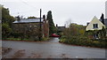
Houses by the B4293, Itton
My first visit to this spot was in December 2006 when I took the First Geograph for the square; Image
Since then I visited the square in 2012; Image, Image
There have been no other contributions to Geograph Project for this square...to date.
Image: © Jonathan Billinger
Taken: 1 Nov 2019
0.02 miles
2
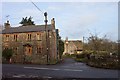
Cottages by the B4293
Looking north from the gridline across Itton Road.
Image: © Jonathan Billinger
Taken: 28 Dec 2006
0.04 miles
3
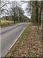
Tree-lined road, Itton, Monmouthshire
Looking to the east along the B4293 towards Chepstow.
Itton Village Hall https://www.geograph.org.uk/photo/7112809 is behind the camera.
Image: © Jaggery
Taken: 6 Mar 2022
0.04 miles
4
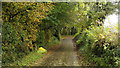
Road to Itton church
Lane rises through autumnal woodland south towards the church and Itton Court.
Image: © Jonathan Billinger
Taken: 1 Nov 2019
0.06 miles
5
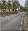
Warning signs, Itton, Monmouthshire
Facing eastbound traffic on the B4293.
Image: © Jaggery
Taken: 6 Mar 2022
0.07 miles
6
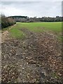
Field on the south side of the B4293, Itton, Monmouthshire
Looking to the ESE from these https://www.geograph.org.uk/photo/7115168 gates.
Image: © Jaggery
Taken: 6 Mar 2022
0.08 miles
7
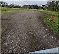
Itton Village Hall car park
Viewed from this https://www.geograph.org.uk/photo/7112977 gate.
Image: © Jaggery
Taken: 6 Mar 2022
0.09 miles
8
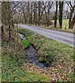
Brook below the B4293, Itton, Monmouthshire
Itton Village Hall https://www.geograph.org.uk/photo/7112809 is behind the camera.
Image: © Jaggery
Taken: 6 Mar 2022
0.11 miles
9
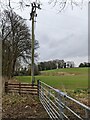
Line spur pole in a field, Itton, Monmouthshire
A rural part of the Western Power Distribution electricity supply infrastructure.
Image: © Jaggery
Taken: 6 Mar 2022
0.13 miles
10
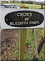
Croes Bleddyn Farm name sign, Itton, Monmouthshire
Facing the B4293, the sign is alongside this https://www.geograph.org.uk/photo/7112945 farm access road.
Image: © Jaggery
Taken: 6 Mar 2022
0.13 miles