IMAGES TAKEN NEAR TO
Whitecliffe View, NP16 5WJ
Introduction
This page details the photographs taken nearby to Whitecliffe View, NP16 5WJ by members of the Geograph project.
The Geograph project started in 2005 with the aim of publishing, organising and preserving representative images for every square kilometre of Great Britain, Ireland and the Isle of Man.

There are currently over 7.5m images from over14,400 individuals and you can help contribute to the project by visiting https://www.geograph.org.uk
Image Map
Images are licensed for reuse under creativecommons.org/licenses/by-sa/2.0
Notes
- Clicking on the map will re-center to the selected point.
- The higher the marker number, the further away the image location is from the centre of the postcode.
Image Listing (130 Images Found)
Images are licensed for reuse under creativecommons.org/licenses/by-sa/2.0
Image
Details
Distance
1
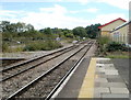
![Chepstow railway station [5]](https://s3.geograph.org.uk/geophotos/07/35/95/7359507_f97ad00f_120x120.jpg)
Chepstow railway station [5]
The lines leading to Newport.
The station was erected in 1850 with the buildings in an Italianate style. Constructed of squared, coursed stone with dressings and quoins in contrasting ashlar, all under a slate roof. The station is on the Gloucester to Newport Line. Until the nearby bridge over the River Wye was opened in 1853 passengers were conveyed by coach between Chepstow East at Tidenham and this station. The station is listed, grade II, with details at: https://cadwpublic-api.azurewebsites.net/reports/listedbuilding/FullReport?lang=&id=2586
Chepstow, the most easterly town in Wales, is located on the tidal River Wye, some 3 miles above its confluence with the River Severn. There is evidence of continuous human occupation from the Mesolithic period. The town grew in importance when the Normans erected a castle at what was the lowest bridging point of the River Wye. The town flourished as a port, being exempt from English taxation, and it mainly traded in timber and bark from the Wye Valley. The town became an important centre for tourism from the late eighteenth century.
Image: © Michael Dibb
Taken: 3 Sep 2022
0.05 miles
2
Ordnance Survey Cut Mark
This OS cut mark can be found on the north side of the railway bridge. It marks a point 18.063m above mean sea level.
Image: © Adrian Dust
Taken: 1 Feb 2022
0.07 miles
3
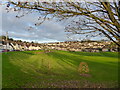
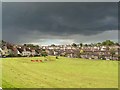
Playing field on Christmas Day 2020, Chepstow Garden City
Image: © Ruth Sharville
Taken: 25 Dec 2020
0.09 miles
4
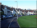
Severn Crescent, Chepstow Garden City
This is the lowest of the hillside roads making up Chepstow Garden City, with an open aspect on to playing fields.
Image: © Ruth Sharville
Taken: 3 Nov 2007
0.10 miles
5
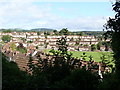
Chepstow Garden City from cycle route 42
Image: © Ruth Sharville
Taken: 3 Sep 2009
0.10 miles
6
The view south from Chepstow Railway Station
The River Wye then the River Severn can be seen from a train for much of the route to the next station, Caldicot.
Image: © Jaggery
Taken: 8 Sep 2010
0.11 miles
7
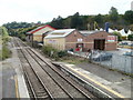
Lineside premises, Chepstow
Viewed from Chepstow railway station footbridge. http://www.geograph.org.uk/photo/811600
Robert Price builders' merchants premises are part of Station Industrial Estate.
Image: © Jaggery
Taken: 17 Sep 2010
0.11 miles
8
Track bed and fenced-off storage area, Chepstow railway station
Maps from several years ago show several railway lines in this area on the east side of the South Wales to Gloucester and Birmingham double track, viewed from Chepstow station platform 1. All that remains now is the track bed, a dilapidated hut in the distance, and fencing enclosing railway sleepers.
Image: © Jaggery
Taken: 17 Sep 2010
0.11 miles
10
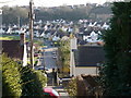
Severn Crescent, and Chepstow Garden City
This view is taken from steps linking the east-west orientated roads of the estate.
Image: © Ruth Sharville
Taken: 27 Mar 2012
0.13 miles