IMAGES TAKEN NEAR TO
Welsh Street, CHEPSTOW, NP16 5UW
Introduction
This page details the photographs taken nearby to Welsh Street, NP16 5UW by members of the Geograph project.
The Geograph project started in 2005 with the aim of publishing, organising and preserving representative images for every square kilometre of Great Britain, Ireland and the Isle of Man.

There are currently over 7.5m images from over14,400 individuals and you can help contribute to the project by visiting https://www.geograph.org.uk
Image Map
Images are licensed for reuse under creativecommons.org/licenses/by-sa/2.0
Notes
- Clicking on the map will re-center to the selected point.
- The higher the marker number, the further away the image location is from the centre of the postcode.
Image Listing (711 Images Found)
Images are licensed for reuse under creativecommons.org/licenses/by-sa/2.0
Image
Details
Distance
1
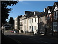
Chepstow - The Moat House
In Welsh Street. The house in the centre of the picture, with the blue door. Other houses in this sunlit row of substantial properties bear names such as "York House" and "Castledale". Most, if not all, appear to be business premises. In the shade at the right is Image
Image: © Roy Parkhouse
Taken: 16 Aug 2007
0.00 miles
2
![Chepstow houses [11]](https://s2.geograph.org.uk/geophotos/07/35/63/7356338_e4e048c3_120x120.jpg)
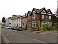
Chepstow houses [11]
Castledale, on the left, and York House are a pair of classic style townhouses built in the mid 19th century. York House was originally Wyecliffe. Constructed of stuccoed brick under a slate roof. There are some ornamental cast-iron balconies and walled forecourt with railings and gates with spear finials. Some original internal features and fittings remain. York House is now used as offices. Listed, grade II, with details at: https://cadwpublic-api.azurewebsites.net/reports/listedbuilding/FullReport?lang=&id=2601
Chepstow, the most easterly town in Wales, is located on the tidal River Wye, some 3 miles above its confluence with the River Severn. There is evidence of continuous human occupation from the Mesolithic period. The town grew in importance when the Normans erected a castle at what was the lowest bridging point of the River Wye. The town flourished as a port, being exempt from English taxation, and it mainly traded in timber and bark from the Wye Valley. The town became an important centre for tourism from the late eighteenth century.
Image: © Michael Dibb
Taken: 2 Sep 2022
0.00 miles
4
![Chepstow houses [10]](https://s0.geograph.org.uk/geophotos/07/35/63/7356336_5c7e8ab9_120x120.jpg)
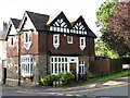
Chepstow houses [10]
Marlborough House, Welsh Street, was built in the mid 19th century. Constructed of roughcast brick under a hipped slate roof. Some original internal features and fittings remain. There is a walled forecourt with railings and a gate with spear finials. Now used as offices. Listed, grade II, with details at: https://cadwpublic-api.azurewebsites.net/reports/listedbuilding/FullReport?lang=&id=2602
Chepstow, the most easterly town in Wales, is located on the tidal River Wye, some 3 miles above its confluence with the River Severn. There is evidence of continuous human occupation from the Mesolithic period. The town grew in importance when the Normans erected a castle at what was the lowest bridging point of the River Wye. The town flourished as a port, being exempt from English taxation, and it mainly traded in timber and bark from the Wye Valley. The town became an important centre for tourism from the late eighteenth century.
Image: © Michael Dibb
Taken: 2 Sep 2022
0.01 miles
5
![Chepstow houses [12]](https://s3.geograph.org.uk/geophotos/07/35/63/7356339_9ef04f72_120x120.jpg)
Chepstow houses [12]
Fairlight, Welsh Street, was built in the mid 19th century. Constructed of rendered brick, lined to simulate ashlar under a hipped pantile roof. Some original internal features and fittings remain. Now used as a dental surgery. Listed, grade II, with details at: https://cadwpublic-api.azurewebsites.net/reports/listedbuilding/FullReport?lang=&id=2600
Chepstow, the most easterly town in Wales, is located on the tidal River Wye, some 3 miles above its confluence with the River Severn. There is evidence of continuous human occupation from the Mesolithic period. The town grew in importance when the Normans erected a castle at what was the lowest bridging point of the River Wye. The town flourished as a port, being exempt from English taxation, and it mainly traded in timber and bark from the Wye Valley. The town became an important centre for tourism from the late eighteenth century.
Image: © Michael Dibb
Taken: 2 Sep 2022
0.01 miles
7
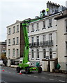
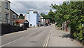
Rooftop chat, Chepstow
Viewed across Welsh Street. A man leaning out of an attic window faces two men in the platform.
Is he saying "Welcome to the party. Sorry the front door is jammed". Perhaps not...
Image: © Jaggery
Taken: 13 Nov 2012
0.01 miles
8
![Chepstow houses [9]](https://s3.geograph.org.uk/geophotos/07/35/63/7356335_6edf374d_120x120.jpg)
Chepstow houses [9]
The Moat House, Welsh Street, was built in the mid 19th century. Constructed of stuccoed brick under a slate roof, Some original internal features remain. There is a walled forecourt with railings and a gate with spear finials. Now converted into flats. Listed, grade II, with details at: https://cadwpublic-api.azurewebsites.net/reports/listedbuilding/FullReport?lang=&id=2603
Chepstow, the most easterly town in Wales, is located on the tidal River Wye, some 3 miles above its confluence with the River Severn. There is evidence of continuous human occupation from the Mesolithic period. The town grew in importance when the Normans erected a castle at what was the lowest bridging point of the River Wye. The town flourished as a port, being exempt from English taxation, and it mainly traded in timber and bark from the Wye Valley. The town became an important centre for tourism from the late eighteenth century.
Image: © Michael Dibb
Taken: 2 Sep 2022
0.01 miles
10
![Chepstow houses [8]](https://s2.geograph.org.uk/geophotos/07/35/63/7356334_f0ae811c_120x120.jpg)
Chepstow houses [8]
Merridale, Welsh Street, was built in the mid 19th century. Constructed of pebbledashed brick under a hipped tile roof. There is a walled forecourt with railings and a gate with spear finials. Listed, grade II, with details at: https://cadwpublic-api.azurewebsites.net/reports/listedbuilding/FullReport?lang=&id=2604
Chepstow, the most easterly town in Wales, is located on the tidal River Wye, some 3 miles above its confluence with the River Severn. There is evidence of continuous human occupation from the Mesolithic period. The town grew in importance when the Normans erected a castle at what was the lowest bridging point of the River Wye. The town flourished as a port, being exempt from English taxation, and it mainly traded in timber and bark from the Wye Valley. The town became an important centre for tourism from the late eighteenth century.
Image: © Michael Dibb
Taken: 2 Sep 2022
0.02 miles