IMAGES TAKEN NEAR TO
St. Kingsmark Avenue, CHEPSTOW, NP16 5SN
Introduction
This page details the photographs taken nearby to St. Kingsmark Avenue, NP16 5SN by members of the Geograph project.
The Geograph project started in 2005 with the aim of publishing, organising and preserving representative images for every square kilometre of Great Britain, Ireland and the Isle of Man.

There are currently over 7.5m images from over14,400 individuals and you can help contribute to the project by visiting https://www.geograph.org.uk
Image Map
Images are licensed for reuse under creativecommons.org/licenses/by-sa/2.0
Notes
- Clicking on the map will re-center to the selected point.
- The higher the marker number, the further away the image location is from the centre of the postcode.
Image Listing (396 Images Found)
Images are licensed for reuse under creativecommons.org/licenses/by-sa/2.0
Image
Details
Distance
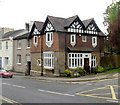
1
Chepstow - mature trees on The Mount
This row of trees includes beech, sycamore, and lime (linden)
The road junction is Welsh Street with Mount Way Nos 1-29.
See also Image and Image
Image: © Roy Parkhouse
Taken: 16 Aug 2007
0.04 miles
2
16 chimney pots, Welsh Street, Chepstow
A building on the lower section of Welsh Street has a chimney stack with 16 chimneypots, two of which are currently in use as bird perches.
Image: © Jaggery
Taken: 1 May 2010
0.04 miles
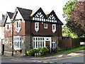
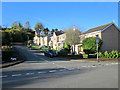
3
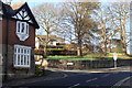
The Lodge, Welsh Street, Chepstow
Located on the corner of Welsh Street and Mount Way. The building is in the records of the Royal Commission on the Ancient and Historical Monuments of Wales, but their website does not have any of the building's history. It dates it with the vague label 'Post Medieval?'. The question mark is theirs.
Image: © Jaggery
Taken: 1 May 2010
0.04 miles
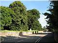
6
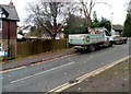
Japanese Knotweed Control vehicle, Chepstow
Parked in Mount Way, the vehicle is used for spraying invasive weeds.
Image: © Jaggery
Taken: 13 Nov 2012
0.08 miles
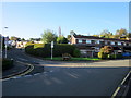
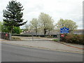
8
Junction of Mount Way and Welsh Street
Image: © Ruth Sharville
Taken: 24 Jan 2009
0.08 miles
9
Exit gate, Dell Primary School, Chepstow
A one-way traffic system operates in the school. The entrance gate is beyond the left edge of the photo, at the northwest edge of the school. This is the exit gate onto Welsh Street, at the southwest edge of the school.
The school building is set a little below the level of Welsh Street.
Image: © Jaggery
Taken: 1 May 2010
0.08 miles