IMAGES TAKEN NEAR TO
Vauxhall Lane, CHEPSTOW, NP16 5PZ
Introduction
This page details the photographs taken nearby to Vauxhall Lane, NP16 5PZ by members of the Geograph project.
The Geograph project started in 2005 with the aim of publishing, organising and preserving representative images for every square kilometre of Great Britain, Ireland and the Isle of Man.

There are currently over 7.5m images from over14,400 individuals and you can help contribute to the project by visiting https://www.geograph.org.uk
Image Map
Images are licensed for reuse under creativecommons.org/licenses/by-sa/2.0
Notes
- Clicking on the map will re-center to the selected point.
- The higher the marker number, the further away the image location is from the centre of the postcode.
Image Listing (348 Images Found)
Images are licensed for reuse under creativecommons.org/licenses/by-sa/2.0
Image
Details
Distance
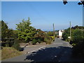
2
Chepstow - Vauxhall Rd and Mounton Rd junction
Central Chepstow is down the hill. The Severn estuary is in the distance.
Image: © Roy Parkhouse
Taken: 24 Aug 2007
0.05 miles
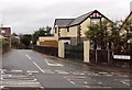
3
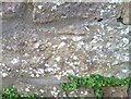
Ordnance Survey Cut Mark
This OS cut mark can be found on Vauxhall House. It marks a point 80.304m above mean sea level.
Image: © Adrian Dust
Taken: 1 Feb 2022
0.05 miles
4
![Chepstow houses [35]](https://s0.geograph.org.uk/geophotos/07/35/68/7356896_43a428b3_120x120.jpg)
Chepstow houses [35]
High Trees, Vauxhall Lane, was built in the early or mid 19th century with later additions and alterations. Converted to become Chepstow Boys Grammar School in 1871 and to District Council offices in 1954. Constructed of rendered brick under a hipped slate roof behind a coped parapet. Some original internal features remain. Listed, grade II, with details at: https://cadwpublic-api.azurewebsites.net/reports/listedbuilding/FullReport?lang=&id=2588
Chepstow, the most easterly town in Wales, is located on the tidal River Wye, some 3 miles above its confluence with the River Severn. There is evidence of continuous human occupation from the Mesolithic period. The town grew in importance when the Normans erected a castle at what was the lowest bridging point of the River Wye. The town flourished as a port, being exempt from English taxation, and it mainly traded in timber and bark from the Wye Valley. The town became an important centre for tourism from the late eighteenth century.
Image: © Michael Dibb
Taken: 2 Sep 2022
0.05 miles
5
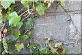
Ordnance Survey Cut Mark
This OS cut mark can be found on the stone post north side of Mounton Road. It marks a point 72.517m above mean sea level.
Image: © Adrian Dust
Taken: 1 Feb 2022
0.06 miles
6

Deans Hill Orchard, Chepstow
Six of the ten apple and pear trees planted on Deans Hill in January 2009. The planting was organised by Transition Chepstow, working with local residents and Chepstow Town Council who purchased the trees. The initiative aims to help restore the apple growing tradition of Chepstow and increase the community's local food growing capabilities. Varieties planted include, Brith Mawr (no info available); Monmouth Green (grown in Black Mountains since Victorian times but variety could be far older; also known as Landore in Herefordshire; dual purpose eater/cooker; late fruiting); King Coffee (eater; late fruiting Nov-Dec); Cissy (Eating apple); Cornish Aromatic (late fruiting Dec-Feb; old fashioned from Cornwall) Introduced in 1813 to England - tolerates wet climate, flavour rich with a hint of pineapple; easy to grow and resistant to main apple diseases). Pear varieties ( 2 trees) are: Beurre Bedford (dessert pear; fruits in Oct; large very juicy firm-fleshed; origin Bedfordshire 1902; pollination group E); Louise Bonne of Jersey (attractive dessert pear with an excellent, distinctive, slightly acid flavour; fruits in Oct-Nov; origin France 1780; pollination group C).
Image: © Marcus Perrin
Taken: 26 Apr 2009
0.07 miles
7
Chepstow - Ruffetts Close and Mounton Rd junction
Image: © Roy Parkhouse
Taken: 24 Aug 2007
0.08 miles
8
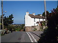
Vauxhall Road, Chepstow
Viewed across the A48.
Image: © Jaggery
Taken: 15 Dec 2013
0.09 miles
10
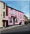
Pink House PARTY Shop, Chepstow
PARTY appears in capitals on the shop sign, perhaps to catch your eye if the bright pink hasn't already done so! Located at 3 Hardwick Terrace, on the corner of the A48, here named Mount Pleasant Road.
Suppliers of balloons, party goods and novelties.
Image: © Jaggery
Taken: 8 Sep 2010
0.09 miles