IMAGES TAKEN NEAR TO
School Hill Trading Estate, CHEPSTOW, NP16 5PH
Introduction
This page details the photographs taken nearby to School Hill Trading Estate, NP16 5PH by members of the Geograph project.
The Geograph project started in 2005 with the aim of publishing, organising and preserving representative images for every square kilometre of Great Britain, Ireland and the Isle of Man.

There are currently over 7.5m images from over14,400 individuals and you can help contribute to the project by visiting https://www.geograph.org.uk
Image Map
Images are licensed for reuse under creativecommons.org/licenses/by-sa/2.0
Notes
- Clicking on the map will re-center to the selected point.
- The higher the marker number, the further away the image location is from the centre of the postcode.
Image Listing (1093 Images Found)
Images are licensed for reuse under creativecommons.org/licenses/by-sa/2.0
Image
Details
Distance
1
Screwfix, Chepstow
Located in Unit 3, School Hill Centre, Screwfix sells DIY,
electrical, bathroom & kitchen products, tools and hardware.
Image: © Jaggery
Taken: 7 Jul 2016
0.02 miles
2
Whirlikidz, Chepstow
Children's indoor soft play centre at 2 School Hill, on the corner of Station Road.
Image: © Jaggery
Taken: 11 Nov 2016
0.02 miles
3
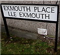
Bilingual name sign Exmouth Place/Lle Exmouth, Chepstow
Located here http://www.geograph.org.uk/photo/2070853. Though there is no letter x in Welsh (taxi is tacsi in Welsh), this sign suggests that there isn't a Welsh name for Exmouth. A literal translation into Welsh would be something like Aberecs.
Image: © Jaggery
Taken: 7 Jul 2016
0.02 miles
4
Chepstow Sorting Office
Like the Jobcentre, this is one of Chepstow's Government buildings of architectural merit. The bathroom showroom opposite is also a very interesting looking building - does anyone know anything about it?
Image: © Ruth Sharville
Taken: 19 Jan 2009
0.02 miles
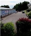
5
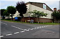
Tree-lined corner in Chepstow
The corner of School Hill (left side) and Station Road.
Image: © Jaggery
Taken: 7 Jul 2016
0.02 miles
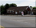
6

Silhouette Dance Club, Chepstow
Viewed from the edge of the A48. The club's address is Upper Nelson Street.
Image: © Jaggery
Taken: 7 Jul 2016
0.03 miles
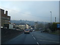
7
Silhouette Dance Club, Chepstow
Viweed across A48. The club's address is Upper Nelson Street.
Image: © Jaggery
Taken: 7 Jul 2016
0.03 miles
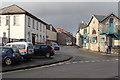
9
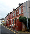
Exmouth Place, Chepstow
A view SE from the A48 end. All 7 houses in Exmouth Place are in this row.
Image: © Jaggery
Taken: 13 Nov 2012
0.03 miles
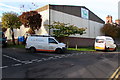
10
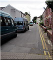
Vans parked in Exmouth Place, Chepstow
Looking to the southeast towards Station Road.
Image: © Jaggery
Taken: 7 Jul 2016
0.03 miles