IMAGES TAKEN NEAR TO
Burnt Barn Road, CHEPSTOW, NP16 5NG
Introduction
This page details the photographs taken nearby to Burnt Barn Road, NP16 5NG by members of the Geograph project.
The Geograph project started in 2005 with the aim of publishing, organising and preserving representative images for every square kilometre of Great Britain, Ireland and the Isle of Man.

There are currently over 7.5m images from over14,400 individuals and you can help contribute to the project by visiting https://www.geograph.org.uk
Image Map
Images are licensed for reuse under creativecommons.org/licenses/by-sa/2.0
Notes
- Clicking on the map will re-center to the selected point.
- The higher the marker number, the further away the image location is from the centre of the postcode.
Image Listing (37 Images Found)
Images are licensed for reuse under creativecommons.org/licenses/by-sa/2.0
Image
Details
Distance
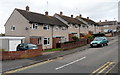
1
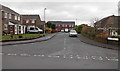
Hawthorn Close, Bulwark, Chepstow
Viewed across Maple Avenue.
Image: © Jaggery
Taken: 15 Dec 2013
0.07 miles
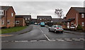
2
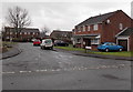
Holly Close, Bulwark, Chepstow
Viewed across Maple Avenue.
Image: © Jaggery
Taken: 15 Dec 2013
0.08 miles
3
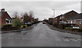
Rowan Drive, Bulwark, Chepstow
Viewed across Maple Avenue looking towards Burnt Barn Road.
Image: © Jaggery
Taken: 15 Dec 2013
0.09 miles
4
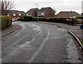
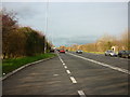
Bend near the SE end of Maple Avenue, Bulwark, Chepstow
Straight as an arrow for 700 metres behind the camera, the course of Maple Avenue bends to the left.
Image: © Jaggery
Taken: 15 Dec 2013
0.12 miles
6
Linden Close, Bulwark, Chepstow
Viewed across Maple Avenue.
Image: © Jaggery
Taken: 15 Dec 2013
0.13 miles
7
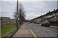
Chepstow : Thornwell Road
Looking down Thornwell Road from the bus stop.
Image: © Lewis Clarke
Taken: 14 Feb 2012
0.13 miles
8
Somerset Way, Bulwark, Chepstow
Viewed from the corner of Thornwell Road.
Image: © Jaggery
Taken: 13 Nov 2012
0.14 miles
9
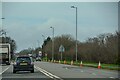
Lay-by on the Wye Valley link road Chepstow
Image: © Steve Fareham
Taken: 28 Jan 2009
0.14 miles
10
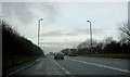
Chepstow : Wye Valley Link Road A466
Looking along the A466.
Image: © Lewis Clarke
Taken: 22 Mar 2023
0.15 miles