IMAGES TAKEN NEAR TO
Kingsmark Lane, CHEPSTOW, NP16 5LZ
Introduction
This page details the photographs taken nearby to Kingsmark Lane, NP16 5LZ by members of the Geograph project.
The Geograph project started in 2005 with the aim of publishing, organising and preserving representative images for every square kilometre of Great Britain, Ireland and the Isle of Man.

There are currently over 7.5m images from over14,400 individuals and you can help contribute to the project by visiting https://www.geograph.org.uk
Image Map
Images are licensed for reuse under creativecommons.org/licenses/by-sa/2.0
Notes
- Clicking on the map will re-center to the selected point.
- The higher the marker number, the further away the image location is from the centre of the postcode.
Image Listing (46 Images Found)
Images are licensed for reuse under creativecommons.org/licenses/by-sa/2.0
Image
Details
Distance
3
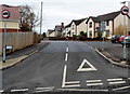
Kingsmark Lane, Chepstow
Kingsmark Lane heads away from Welsh Street. The far end of the lane is at the St Lawrence Road junction.
Image: © Jaggery
Taken: 13 Nov 2012
0.08 miles
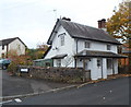
4
Chepstow - Crossway Green Toll House
On the corner of Welsh Street and Kingsmark Lane. Built 1758 according to "Turnpike Roads" by Ivor Waters.
Grade II listed 31 Oct 1972 see https://britishlistedbuildings.co.uk/300002605-pike-house-chepstow
Milestone Society National ID: MON.CHE01
Image: © Roy Parkhouse
Taken: 10 Apr 2006
0.10 miles
5
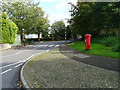
Welsh Street, Chepstow
Showing position of Postbox No. NP16 421.
See Image] for postbox.
Image: © JThomas
Taken: 15 Oct 2019
0.11 miles
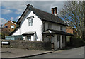
6
Grade II listed Pike Cottage, Chepstow
Located on the corner of Welsh Street and Kingsmark Lane, this dwelling was built in the early 19th century as a tollhouse cottage. The Pike in its name is a shortened form of turnpike. Some sources show the name as Pyke House. Grade II listed in October 1972.
Image: © Jaggery
Taken: 13 Nov 2012
0.11 miles
7
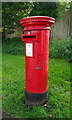
Elizabeth II postbox on Welsh Street, Chepstow
Postbox No. NP16 421.
See Image] for context.
Image: © JThomas
Taken: 15 Oct 2019
0.11 miles
8
![Chepstow houses [5]](https://s0.geograph.org.uk/geophotos/07/35/56/7355616_8d663429_120x120.jpg)
Chepstow houses [5]
Pyke House, Welsh Street, appears to be an early or mid 19th century toll-house on a turnpike road, but it was reputedly originally built in 1758. Constructed in Gothick style of rendered brick under a slate roof. There is a verandah to the front and two lean-to extensions. Listed, grade II, with details at: https://cadwpublic-api.azurewebsites.net/reports/listedbuilding/FullReport?lang=&id=2605
Chepstow, the most easterly town in Wales, is located on the tidal River Wye, some 3 miles above its confluence with the River Severn. There is evidence of continuous human occupation from the Mesolithic period. The town grew in importance when the Normans erected a castle at what was the lowest bridging point of the River Wye. The town flourished as a port, being exempt from English taxation, and it mainly traded in timber and bark from the Wye Valley. The town became an important centre for tourism from the late eighteenth century.
Image: © Michael Dibb
Taken: 2 Sep 2022
0.11 miles