IMAGES TAKEN NEAR TO
Castle Gardens, CHEPSTOW, NP16 5LF
Introduction
This page details the photographs taken nearby to Castle Gardens, NP16 5LF by members of the Geograph project.
The Geograph project started in 2005 with the aim of publishing, organising and preserving representative images for every square kilometre of Great Britain, Ireland and the Isle of Man.

There are currently over 7.5m images from over14,400 individuals and you can help contribute to the project by visiting https://www.geograph.org.uk
Image Map
Images are licensed for reuse under creativecommons.org/licenses/by-sa/2.0
Notes
- Clicking on the map will re-center to the selected point.
- The higher the marker number, the further away the image location is from the centre of the postcode.
Image Listing (74 Images Found)
Images are licensed for reuse under creativecommons.org/licenses/by-sa/2.0
Image
Details
Distance
1
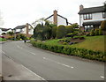
Mount Way, Chepstow
Mount Way is a discontinuous residential road. The southern part connects with Welsh Street about 100 metres away. The northern part, seen here, leads from Welsh Street to numbers 30 to 42 Mount Way.
Image: © Jaggery
Taken: 1 May 2010
0.04 miles
2
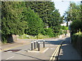
Mount Way Nos 30-42 and Welsh St junction
Image: © Roy Parkhouse
Taken: 22 Aug 2007
0.06 miles
3
![Chepstow features [12]](https://s3.geograph.org.uk/geophotos/07/35/56/7355643_b02ef4cb_120x120.jpg)
Chepstow features [12]
Entrance gates to The Mount, probably mid 19th century. Four tall rectangular iron piers supporting double gates and similar narrow pedestrian gates on either side. Listed, grade II, with details at: https://cadwpublic-api.azurewebsites.net/reports/listedbuilding/FullReport?lang=&id=27107
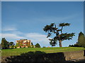
Chepstow, the most easterly town in Wales, is located on the tidal River Wye, some 3 miles above its confluence with the River Severn. There is evidence of continuous human occupation from the Mesolithic period. The town grew in importance when the Normans erected a castle at what was the lowest bridging point of the River Wye. The town flourished as a port, being exempt from English taxation, and it mainly traded in timber and bark from the Wye Valley. The town became an important centre for tourism from the late eighteenth century.
Image: © Michael Dibb
Taken: 2 Sep 2022
0.06 miles
5
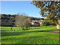
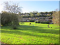
St Kingsmark Avenue Recreation Ground Chepstow
Image: © Roy Hughes
Taken: 27 Oct 2017
0.09 miles
6
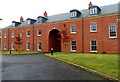
The Courtyard apartments, The Mount, Chepstow
Accessed through the archway, The Courtyard is a recent Bovale development, containing 20 new apartments. Viewed from the edge of Welsh Street.
Image: © Jaggery
Taken: 13 Nov 2012
0.09 miles
8
St Kingsmark Avenue Recreation Ground Chepstow (2)
Image: © Roy Hughes
Taken: 27 Oct 2017
0.11 miles
10
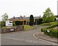
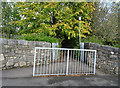
Entrance to The Dell Primary School, Chepstow
Image: © JThomas
Taken: 15 Oct 2019
0.12 miles