IMAGES TAKEN NEAR TO
Church Row, CHEPSTOW, NP16 5HN
Introduction
This page details the photographs taken nearby to Church Row, NP16 5HN by members of the Geograph project.
The Geograph project started in 2005 with the aim of publishing, organising and preserving representative images for every square kilometre of Great Britain, Ireland and the Isle of Man.

There are currently over 7.5m images from over14,400 individuals and you can help contribute to the project by visiting https://www.geograph.org.uk
Image Map
Images are licensed for reuse under creativecommons.org/licenses/by-sa/2.0
Notes
- Clicking on the map will re-center to the selected point.
- The higher the marker number, the further away the image location is from the centre of the postcode.
Image Listing (1088 Images Found)
Images are licensed for reuse under creativecommons.org/licenses/by-sa/2.0
Image
Details
Distance
2
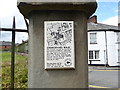
Churchyard Walk plaque, St Mary's Church
Image: © Eirian Evans
Taken: 22 Jul 2015
0.01 miles
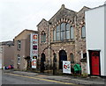
3
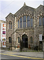
Chepstow Baptist church
Baptism had taken root in Chepstow since the times of Cromwell, but it wasn't until the early 1800s that a proper place of worship was built. Local man Walter Watkin was asked to fashion the church on "a part and parcel of an orchard then in the occupation of John Penn near the Churchyard" (the yard being referred to is the nearby St Mary's Priory). The church officially opened its doors in 1816; subsequent extensions were made in 1867 and a small Sunday school added - education being a particular mission for the ministers here.
Image: © Neil Owen
Taken: 7 Aug 2013
0.01 miles
4
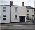
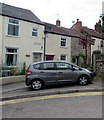
Clare Cottage and Hope Cottage, Lower Church Street, Chepstow
Adjacent blue front doors near Church Row on the right.
Image: © Jaggery
Taken: 7 Jul 2016
0.01 miles
6
![Chepstow buildings [77]](https://s1.geograph.org.uk/geophotos/07/35/83/7358353_e5a69436_120x120.jpg)
Chepstow buildings [77]
Chepstow Baptist Church, Lower Church Street, was built, in the Romanesque style, as a chapel in 1816 and enlarged in 1869. Constructed of rubble stone with freestone dressings under a slate roof.
Chepstow, the most easterly town in Wales, is located on the tidal River Wye, some 3 miles above its confluence with the River Severn. There is evidence of continuous human occupation from the Mesolithic period. The town grew in importance when the Normans erected a castle at what was the lowest bridging point of the River Wye. The town flourished as a port, being exempt from English taxation, and it mainly traded in timber and bark from the Wye Valley. The town became an important centre for tourism from the late eighteenth century.
Image: © Michael Dibb
Taken: 3 Sep 2022
0.01 miles
7
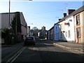
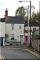
Lower Church Street, Chepstow
Towards Church Road and the town centre.
Image: © Jaggery
Taken: 7 Jul 2016
0.02 miles
8
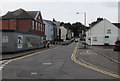
Signpost on a Chepstow corner
On the corner of Church Row and Lower Church Street at the edge of St Mary's churchyard.
Image: © Jaggery
Taken: 7 Jul 2016
0.02 miles
9
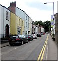
Lower Church Street, Chepstow
From the corner of St Ann Street and The Back along Lower Church Street towards Church Road.
Image: © Jaggery
Taken: 7 Jul 2016
0.02 miles
10
Chepstow Baptist Church
Viewed from Church Road. The church, located on the corner of Lower Church Street and Myrtle Place, first opened for worship in 1816. It was built in the Romanesque and Lombardic/Italian style.
The church building was enlarged in 1869, and a new Sunday School was added at the rear. See https://www.geograph.org.uk/photo/5667393
Image: © Jaggery
Taken: 13 Nov 2012
0.02 miles