IMAGES TAKEN NEAR TO
Tenby Lane, CHEPSTOW, NP16 5GH
Introduction
This page details the photographs taken nearby to Tenby Lane, NP16 5GH by members of the Geograph project.
The Geograph project started in 2005 with the aim of publishing, organising and preserving representative images for every square kilometre of Great Britain, Ireland and the Isle of Man.

There are currently over 7.5m images from over14,400 individuals and you can help contribute to the project by visiting https://www.geograph.org.uk
Image Map
Images are licensed for reuse under creativecommons.org/licenses/by-sa/2.0
Notes
- Clicking on the map will re-center to the selected point.
- The higher the marker number, the further away the image location is from the centre of the postcode.
Image Listing (121 Images Found)
Images are licensed for reuse under creativecommons.org/licenses/by-sa/2.0
Image
Details
Distance
1
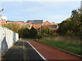
New housing estate overlooking the Wye Bridge
The red cycle track turns to the right to go under the M48 through a tunnelImage
Image: © Ruth Sharville
Taken: 27 Oct 2009
0.01 miles
2
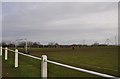
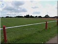
Chepstow : Football Pitch
A football pitch off of Tenby Lane with the Wye and Severn Bridge in the distance.
Image: © Lewis Clarke
Taken: 14 Feb 2012
0.04 miles
3
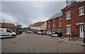
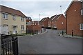
Chepstow : Samuel Rodgers Crescent
Looking along houses in Samuel Rodgers Crescent on the edge of Chepstow.
Image: © Lewis Clarke
Taken: 14 Feb 2012
0.04 miles
4
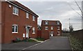
Chepstow : James Stephens Way
Looking at houses on James Stephens Way on the outskirts of Chepstow.
Image: © Lewis Clarke
Taken: 14 Feb 2012
0.05 miles
5
Chepstow : James Stephens Way
Looking along James Stephens Way on the outskirts of Chepstow.
Image: © Lewis Clarke
Taken: 14 Feb 2012
0.05 miles
6
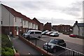
Chepstow : James Stephens Way
Looking from Denbigh Drive towards James Stephens Way with ample car parking space.
Image: © Lewis Clarke
Taken: 14 Feb 2012
0.06 miles
7

Grade II listed former Thornwell Farmhouse, Chepstow
The Georgian L-shaped former farmhouse has been renovated and converted to flats. When the building was Grade II listed in March 1952, it was an isolated building in farmland a mile south of houses in Bulwark. The former farmhouse is now surrounded by housing built in the final decade of the 20th century and the first decade of the 21st century.
Image: © Jaggery
Taken: 13 Nov 2012
0.06 miles
8
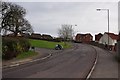
Chepstow : Denbigh Drive
Denbigh Drive heading up the hill with a bike coming out from Fountain Way.
Image: © Lewis Clarke
Taken: 14 Feb 2012
0.06 miles
10
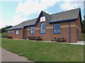
Thornwell Pavilion
Home of Thornwell F.C., plays in the Gwent County League.
Image: © Eirian Evans
Taken: 22 Jul 2015
0.06 miles