IMAGES TAKEN NEAR TO
James Stephens Way, CHEPSTOW, NP16 5GE
Introduction
This page details the photographs taken nearby to James Stephens Way, NP16 5GE by members of the Geograph project.
The Geograph project started in 2005 with the aim of publishing, organising and preserving representative images for every square kilometre of Great Britain, Ireland and the Isle of Man.

There are currently over 7.5m images from over14,400 individuals and you can help contribute to the project by visiting https://www.geograph.org.uk
Image Map
Images are licensed for reuse under creativecommons.org/licenses/by-sa/2.0
Notes
- Clicking on the map will re-center to the selected point.
- The higher the marker number, the further away the image location is from the centre of the postcode.
Image Listing (126 Images Found)
Images are licensed for reuse under creativecommons.org/licenses/by-sa/2.0
Image
Details
Distance
1
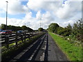
Chepstow : James Stephens Way
Looking along James Stephens Way on the outskirts of Chepstow.
Image: © Lewis Clarke
Taken: 14 Feb 2012
0.01 miles
2
New housing estate overlooking the Wye Bridge
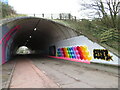
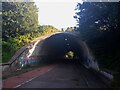
The red cycle track turns to the right to go under the M48 through a tunnelImage
Image: © Ruth Sharville
Taken: 27 Oct 2009
0.03 miles
3
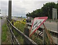
M48 verge
An upended warning sign and cluster of evening primrose by the motorway.
Image: © Mike Parker
Taken: 7 Jul 2022
0.03 miles
4
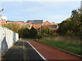
Cycle track beside the M48 Motorway
Towards Chepstow.
Image: © JThomas
Taken: 15 Oct 2019
0.04 miles
5
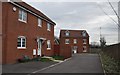
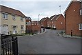
Chepstow : James Stephens Way
Looking at houses on James Stephens Way on the outskirts of Chepstow.
Image: © Lewis Clarke
Taken: 14 Feb 2012
0.04 miles
6
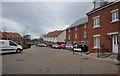
Chepstow : Samuel Rodgers Crescent
Looking along houses in Samuel Rodgers Crescent on the edge of Chepstow.
Image: © Lewis Clarke
Taken: 14 Feb 2012
0.05 miles
7
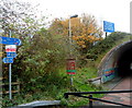
Signs at the northern edge of a tunnel under the M48 near Chepstow
The signs are near the northern portal of this http://www.geograph.org.uk/photo/3341816 tunnel.
A sign pointing towards the tunnel shows that this is National Cycle Network
route 4 for Aust and Bristol. This way also for route 41 to Gloucester.
A sign on the motorway, at the approach to the contiguous Wye Bridge
and Severn Bridge, shows For 2½ miles No repairs in emergency use telephone.
Image: © Jaggery
Taken: 13 Nov 2012
0.06 miles
8
Caerwent Lane Underpass, Thornwell
Caerwent Lane Underpass in Thornwell under the M48, built in 1966.
Image: © s
Taken: 23 Aug 2021
0.06 miles
9
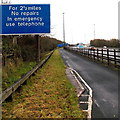
No repairs for 2? miles ahead on the M48 east of Chepstow
The sign is on the approach to the contiguous Wye Bridge and Severn Bridge. In an emergency, use telephone.
Image: © Jaggery
Taken: 15 Dec 2013
0.06 miles