IMAGES TAKEN NEAR TO
Bridge Street, CHEPSTOW, NP16 5EZ
Introduction
This page details the photographs taken nearby to Bridge Street, NP16 5EZ by members of the Geograph project.
The Geograph project started in 2005 with the aim of publishing, organising and preserving representative images for every square kilometre of Great Britain, Ireland and the Isle of Man.

There are currently over 7.5m images from over14,400 individuals and you can help contribute to the project by visiting https://www.geograph.org.uk
Image Map
Images are licensed for reuse under creativecommons.org/licenses/by-sa/2.0
Notes
- Clicking on the map will re-center to the selected point.
- The higher the marker number, the further away the image location is from the centre of the postcode.
Image Listing (893 Images Found)
Images are licensed for reuse under creativecommons.org/licenses/by-sa/2.0
Image
Details
Distance
1
![Chepstow houses [58]](https://s1.geograph.org.uk/geophotos/07/35/89/7358909_4f1cb561_120x120.jpg)
Chepstow houses [58]
Number 19 Bridge Street was built in the late 18th or early 19th century, possibly incorporating some earlier fabric. Constructed of rendered brick under a slate roof. Listed, grade II, with details at: https://cadwpublic-api.azurewebsites.net/reports/listedbuilding/FullReport?lang=&id=2512
Chepstow, the most easterly town in Wales, is located on the tidal River Wye, some 3 miles above its confluence with the River Severn. There is evidence of continuous human occupation from the Mesolithic period. The town grew in importance when the Normans erected a castle at what was the lowest bridging point of the River Wye. The town flourished as a port, being exempt from English taxation, and it mainly traded in timber and bark from the Wye Valley. The town became an important centre for tourism from the late eighteenth century.
Image: © Michael Dibb
Taken: 3 Sep 2022
0.00 miles
2
![Chepstow houses [59]](https://s2.geograph.org.uk/geophotos/07/35/89/7358910_e7a888ea_120x120.jpg)
Chepstow houses [59]
The Boat House, number 20 bridge Street, was possibly originally a store, dating from the late 18th or early 19th century. Constructed of rendered brick under a very long pitched slate roof. Listed, grade II, with details at: https://cadwpublic-api.azurewebsites.net/reports/listedbuilding/FullReport?lang=&id=27088
Chepstow, the most easterly town in Wales, is located on the tidal River Wye, some 3 miles above its confluence with the River Severn. There is evidence of continuous human occupation from the Mesolithic period. The town grew in importance when the Normans erected a castle at what was the lowest bridging point of the River Wye. The town flourished as a port, being exempt from English taxation, and it mainly traded in timber and bark from the Wye Valley. The town became an important centre for tourism from the late eighteenth century.
Image: © Michael Dibb
Taken: 3 Sep 2022
0.00 miles
3
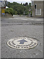
Heritage trail around Chepstow
Dotted around the town are a number of these ceramic markers.
Image: © Neil Owen
Taken: 7 Aug 2013
0.01 miles
4

Chepstow Museum
In an elegant late 18th Century town house, at the bottom of the town near the river. The house, known as Gwy House, was built in 1796 by Warren Jane the Younger, an Apothecary. It was owned for many years in the 19th century by a respected local surgeon, later becoming a Red Cross Hospital for soldiers in the First World War and until recently was the Chepstow & District Hospital. A display in the museum vividly illustrates the changing uses of the building over the years.
The museum's exhibits reflect the development of Chepstow, once an important port and bustling market town. The displays show the growth and decline of the port with its valuable wine and timber trades. Shipbuilding and salmon fishing and many other aspects of Chepstow's working life are shown in imaginative settings which recapture an essence of the original scenes. Pleasures and pastimes are recalled in original photographs, programmes and posters.
Image: © Eirian Evans
Taken: 2 Dec 2011
0.01 miles
5
![Chepstow houses [62]](https://s2.geograph.org.uk/geophotos/07/35/94/7359494_56d428a5_120x120.jpg)
Chepstow houses [62]
On the corner of Bridge Street and St Ann Street, this large house has been converted into apartments, numbered 21, 21A, 22 and 22A Bridge Street. Probably built in the 16th or 17th century, refronted in the late 18th or early 19th century and mostly rebuilt in the late 20th century incorporating a Victorian former shopfront. Constructed of rendered brick, lined to simulate ashlar, under a slate roof. Listed, grade II, with details at: https://cadwpublic-api.azurewebsites.net/reports/listedbuilding/FullReport?lang=&id=2513
Chepstow, the most easterly town in Wales, is located on the tidal River Wye, some 3 miles above its confluence with the River Severn. There is evidence of continuous human occupation from the Mesolithic period. The town grew in importance when the Normans erected a castle at what was the lowest bridging point of the River Wye. The town flourished as a port, being exempt from English taxation, and it mainly traded in timber and bark from the Wye Valley. The town became an important centre for tourism from the late eighteenth century.
Image: © Michael Dibb
Taken: 3 Sep 2022
0.01 miles
6
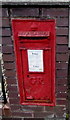
King George V postbox, St Ann Street, Chepstow
On the right here. http://www.geograph.org.uk/photo/5263074
The GR on the box is short for Georgius Rex,
Latin for King George, in this case King George V
who reigned from May 1910-January 1936.
Image: © Jaggery
Taken: 7 Jul 2016
0.01 miles
7
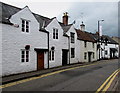
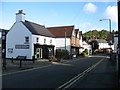
St Ann Street houses, Chepstow
St Ann Street is between Bridge Street and Lower Church Street.
Double yellow lines on both sides indicate no parking at any time.
Image: © Jaggery
Taken: 7 Jul 2016
0.01 miles
8
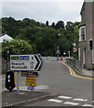
Distances from a Chepstow junction
The sign facing Bridge Street points towards St Ann's Street, 17 miles from Newport and 17 miles from Monmouth. Other signs point the same way, to a Baptist church, an alternative car park and a cycle route.
Image: © Jaggery
Taken: 7 Jul 2016
0.01 miles
9
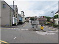
All traffic turn left here, Bridge Street, Chepstow
The sign directs all traffic from Bridge Street into St Ann Street. http://www.geograph.org.uk/photo/5263011
Image: © Jaggery
Taken: 7 Jul 2016
0.01 miles
10
Bridge Street, Chepstow
There is a car park on the left, below the castle. The slip road on the left is the exit from there, into the (one-way) Bridge Street. A short distance ahead, there are just two options: double back into the centre of Chepstow, or cross the old bridge across the River Wye into England.
Image: © David Purchase
Taken: 9 Oct 2016
0.01 miles