IMAGES TAKEN NEAR TO
Middle Street, CHEPSTOW, NP16 5ET
Introduction
This page details the photographs taken nearby to Middle Street, NP16 5ET by members of the Geograph project.
The Geograph project started in 2005 with the aim of publishing, organising and preserving representative images for every square kilometre of Great Britain, Ireland and the Isle of Man.

There are currently over 7.5m images from over14,400 individuals and you can help contribute to the project by visiting https://www.geograph.org.uk
Image Map
Images are licensed for reuse under creativecommons.org/licenses/by-sa/2.0
Notes
- Clicking on the map will re-center to the selected point.
- The higher the marker number, the further away the image location is from the centre of the postcode.
Image Listing (1205 Images Found)
Images are licensed for reuse under creativecommons.org/licenses/by-sa/2.0
Image
Details
Distance
1
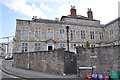
Powis Almshouses, Bridge Street
Image: © Nick Mutton 01329 000000
Taken: 5 Jul 2010
0.00 miles
2
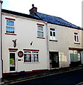
The Beauty Spot, Middle Street, Chepstow
Beauty salon at 6 Middle Street.
Image: © Jaggery
Taken: 11 Nov 2016
0.00 miles
3
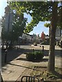
Chepstow High Street
Loverly with out the traffic.
Image: © Peter Randall-Cook
Taken: 9 Oct 2021
0.01 miles
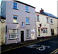
4
![Chepstow buildings [73]](https://s0.geograph.org.uk/geophotos/07/35/78/7357884_cd8affd3_120x120.jpg)
Chepstow buildings [73]
Number 10 Middle Street is probably a 17th century shop and former warehouse. Constructed of rendered rubble stone under a tile roof. The shopfront is late 19th century. Listed, grade II, with details at: https://cadwpublic-api.azurewebsites.net/reports/listedbuilding/FullReport?lang=&id=2555
Chepstow, the most easterly town in Wales, is located on the tidal River Wye, some 3 miles above its confluence with the River Severn. There is evidence of continuous human occupation from the Mesolithic period. The town grew in importance when the Normans erected a castle at what was the lowest bridging point of the River Wye. The town flourished as a port, being exempt from English taxation, and it mainly traded in timber and bark from the Wye Valley. The town became an important centre for tourism from the late eighteenth century.
Image: © Michael Dibb
Taken: 3 Sep 2022
0.01 miles
5
Lavish in Chepstow
Hairdressers at 7 Middle Street, next door to The Beauty Spot salon. http://www.geograph.org.uk/photo/5189933
Image: © Jaggery
Taken: 11 Nov 2016
0.01 miles
6
![Chepstow buildings [70]](https://s0.geograph.org.uk/geophotos/07/35/78/7357868_e158fc52_120x120.jpg)
Chepstow buildings [70]
Number 22 St Mary Street was, probably, built in the late 18th century as a small townhouse, now an office with accommodation above. Constructed of stuccoed rubble stone, lined to simulate ashlar, under a slate roof. Listed, grade II, with details at: https://cadwpublic-api.azurewebsites.net/reports/listedbuilding/FullReport?lang=&id=2584
Image: © Michael Dibb
Taken: 3 Sep 2022
0.01 miles
7
Powis Almshouses, Bridge Street
Image: © Nick Mutton 01329 000000
Taken: 5 Jul 2010
0.01 miles
8
![Chepstow buildings [69]](https://s3.geograph.org.uk/geophotos/07/35/78/7357867_0d77bd5d_120x120.jpg)
Chepstow buildings [69]
Number 21 St Mary Street was, probably, built in the early 19th century and remodelled in the 20th century. Constructed of rendered brick, lined to simulate ashlar, under a tile roof. The multipane shopfront is 20th century. To the rear, the early courtyard of Otter Court is retained. Listed, grade II, with details at: https://cadwpublic-api.azurewebsites.net/reports/listedbuilding/FullReport?lang=&id=27095
Chepstow, the most easterly town in Wales, is located on the tidal River Wye, some 3 miles above its confluence with the River Severn. There is evidence of continuous human occupation from the Mesolithic period. The town grew in importance when the Normans erected a castle at what was the lowest bridging point of the River Wye. The town flourished as a port, being exempt from English taxation, and it mainly traded in timber and bark from the Wye Valley. The town became an important centre for tourism from the late eighteenth century.
Image: © Michael Dibb
Taken: 3 Sep 2022
0.01 miles
9
![Chepstow buildings [71]](https://s1.geograph.org.uk/geophotos/07/35/78/7357877_8fef37c1_120x120.jpg)
Chepstow buildings [71]
Bowsher House, number 23 St Mary Street, was built in the 18th century as a townhouse and converted, in the 19th century, into a two-storey shop with separate two-storey living accommodation above. Constructed of rendered rubble stone, lined to simulate ashlar under a hipped Welsh slate roof. The shopfront is 20th century. Listed, grade II, with details at: https://cadwpublic-api.azurewebsites.net/reports/listedbuilding/FullReport?lang=&id=2585
Chepstow, the most easterly town in Wales, is located on the tidal River Wye, some 3 miles above its confluence with the River Severn. There is evidence of continuous human occupation from the Mesolithic period. The town grew in importance when the Normans erected a castle at what was the lowest bridging point of the River Wye. The town flourished as a port, being exempt from English taxation, and it mainly traded in timber and bark from the Wye Valley. The town became an important centre for tourism from the late eighteenth century.
Image: © Michael Dibb
Taken: 3 Sep 2022
0.01 miles
10
![Chepstow houses [36]](https://s3.geograph.org.uk/geophotos/07/35/78/7357887_af76c7ee_120x120.jpg)
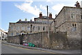
Chepstow houses [36]
Number 11 Middle Street and number 12 Middles Street (nearest the camera) were built, probably, in the late 18th century. Both are constructed of rendered rubble stone, lined to simulate ashlar. Number 12 has a slate roof. The roof of number is tile at the front and slate at the rear. Both houses have rear elevations to Hocker Hill Street and the main entrances are now there. Listed, grade II, with details at: https://cadwpublic-api.azurewebsites.net/reports/listedbuilding/FullReport?lang=&id=2556 (number 11) and at: https://cadwpublic-api.azurewebsites.net/reports/listedbuilding/FullReport?lang=&id=2557 (number 12).
Chepstow, the most easterly town in Wales, is located on the tidal River Wye, some 3 miles above its confluence with the River Severn. There is evidence of continuous human occupation from the Mesolithic period. The town grew in importance when the Normans erected a castle at what was the lowest bridging point of the River Wye. The town flourished as a port, being exempt from English taxation, and it mainly traded in timber and bark from the Wye Valley. The town became an important centre for tourism from the late eighteenth century.
Image: © Michael Dibb
Taken: 3 Sep 2022
0.01 miles