IMAGES TAKEN NEAR TO
Beaufort Square, CHEPSTOW, NP16 5EP
Introduction
This page details the photographs taken nearby to Beaufort Square, NP16 5EP by members of the Geograph project.
The Geograph project started in 2005 with the aim of publishing, organising and preserving representative images for every square kilometre of Great Britain, Ireland and the Isle of Man.

There are currently over 7.5m images from over14,400 individuals and you can help contribute to the project by visiting https://www.geograph.org.uk
Image Map
Images are licensed for reuse under creativecommons.org/licenses/by-sa/2.0
Notes
- Clicking on the map will re-center to the selected point.
- The higher the marker number, the further away the image location is from the centre of the postcode.
Image Listing (1159 Images Found)
Images are licensed for reuse under creativecommons.org/licenses/by-sa/2.0
Image
Details
Distance
1
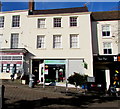
Oxfam shop, Beaufort Square, Chepstow
This is one of c700 Oxfam shops in the UK. Oxfam was founded in Oxford in 1942 as the Oxford Committee for Famine Relief by a group of Quakers, social activists and Oxford academics. It changed its name to Oxfam in 1965.
Image: © Jaggery
Taken: 11 Nov 2016
0.00 miles
2
![Chepstow buildings [56]](https://s1.geograph.org.uk/geophotos/07/35/75/7357553_7281b656_120x120.jpg)
Chepstow buildings [56]
Number 11 Beaufort Square, a shop with accommodation above, was built in the late 18th or early 19th century. Constructed of rendered brick, lined to simulate ashlar under a slate roof. Beaufort Square was formerly the Market Place, called The Square, also St Mary's Square and the Beast Market, the present name dates from the 18th century. Listed, grade II, with details at: https://cadwpublic-api.azurewebsites.net/reports/listedbuilding/FullReport?lang=&id=2500
Chepstow, the most easterly town in Wales, is located on the tidal River Wye, some 3 miles above its confluence with the River Severn. There is evidence of continuous human occupation from the Mesolithic period. The town grew in importance when the Normans erected a castle at what was the lowest bridging point of the River Wye. The town flourished as a port, being exempt from English taxation, and it mainly traded in timber and bark from the Wye Valley. The town became an important centre for tourism from the late eighteenth century.
Image: © Michael Dibb
Taken: 3 Sep 2022
0.00 miles
3
![Chepstow buildings [55]](https://s3.geograph.org.uk/geophotos/07/35/75/7357547_237f16dc_120x120.jpg)
Chepstow buildings [55]
Number 10 Beaufort Square, a shop with accommodation above, formerly called Nell Gwynne House, was built in the late 18th or early 19th century. Constructed of rendered brick under a slate roof. The shopfront is 20th century. Beaufort Square was formerly the Market Place, called The Square, also St Mary's Square and the Beast Market, the present name dates from the 18th century. Listed, grade II, with details at: https://cadwpublic-api.azurewebsites.net/reports/listedbuilding/FullReport?lang=&id=2499
Chepstow, the most easterly town in Wales, is located on the tidal River Wye, some 3 miles above its confluence with the River Severn. There is evidence of continuous human occupation from the Mesolithic period. The town grew in importance when the Normans erected a castle at what was the lowest bridging point of the River Wye. The town flourished as a port, being exempt from English taxation, and it mainly traded in timber and bark from the Wye Valley. The town became an important centre for tourism from the late eighteenth century.
Image: © Michael Dibb
Taken: 3 Sep 2022
0.00 miles
4
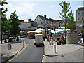
Continental Market in Beaufort Square, Chepstow
The Continental Market extended all the way up the High Street, as far as the Town Arch. Traffic was diverted.
Image: © Roy Parkhouse
Taken: 1 Jul 2006
0.01 miles
5
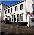
HSBC Chepstow
Town centre bank branch at 12 Beaufort Square.
Image: © Jaggery
Taken: 11 Nov 2016
0.01 miles
6
![Chepstow buildings [54]](https://s1.geograph.org.uk/geophotos/07/35/75/7357541_91b2d283_120x120.jpg)
Chepstow buildings [54]
Number 9 Beaufort Square was, probably, built in the 18th century and altered in both the 19th and 20th centuries. Constructed of stuccoed brick under a tile roof with a large 20th century projecting shopfront. Beaufort Square was formerly the Market Place, called The Square, also St Mary's Square and the Beast Market, the present name dates from the 18th century. Listed, grade II, with details at: https://cadwpublic-api.azurewebsites.net/reports/listedbuilding/FullReport?lang=&id=2498
Chepstow, the most easterly town in Wales, is located on the tidal River Wye, some 3 miles above its confluence with the River Severn. There is evidence of continuous human occupation from the Mesolithic period. The town grew in importance when the Normans erected a castle at what was the lowest bridging point of the River Wye. The town flourished as a port, being exempt from English taxation, and it mainly traded in timber and bark from the Wye Valley. The town became an important centre for tourism from the late eighteenth century.
Image: © Michael Dibb
Taken: 3 Sep 2022
0.01 miles
7
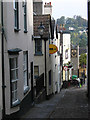
Chepstow - view down Hocker Hill Street
For a view in the other direction, please see Image
Image: © Dave Bevis
Taken: 1 Oct 2011
0.01 miles
8
NatWest Cymru, Chepstow
Town centre bank branch in Beaufort Square.
NatWest name signs in Wales now show NatWest Cymru. Cymru is the Welsh word for Wales. The company's website states that NatWest actively encourages the use of Welsh in the workplace and has been an active supporter of the Welsh Language Board’s Investing in Welsh Marque initiative. It has incorporated the Working Welsh logo into the design of its corporate name badges which are worn by all branch staff in customer contact roles. The badges identify Welsh speaking staff and indicate whether they are fluent in, or learning, the language.
Image: © Jaggery
Taken: 11 Nov 2016
0.01 miles
9
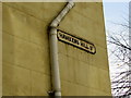
Hawkers Hill St name sign, Chepstow
Most modern references and maps have HOCKER HILL STREET.
Does this sign show the obsolete older version of the name,
or is it a variant which is also in current use?
Image: © Jaggery
Taken: 11 Nov 2016
0.01 miles
10
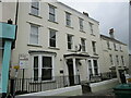
St Maur, Chepstow
Dates from 1732 but with alterations https://cadwpublic-api.azurewebsites.net/reports/listedbuilding/FullReport?lang=&id=2543
Image: © Jonathan Thacker
Taken: 16 Nov 2021
0.01 miles