IMAGES TAKEN NEAR TO
Bank Street, CHEPSTOW, NP16 5EN
Introduction
This page details the photographs taken nearby to Bank Street, NP16 5EN by members of the Geograph project.
The Geograph project started in 2005 with the aim of publishing, organising and preserving representative images for every square kilometre of Great Britain, Ireland and the Isle of Man.

There are currently over 7.5m images from over14,400 individuals and you can help contribute to the project by visiting https://www.geograph.org.uk
Image Map
Images are licensed for reuse under creativecommons.org/licenses/by-sa/2.0
Notes
- Clicking on the map will re-center to the selected point.
- The higher the marker number, the further away the image location is from the centre of the postcode.
Image Listing (1123 Images Found)
Images are licensed for reuse under creativecommons.org/licenses/by-sa/2.0
Image
Details
Distance
1
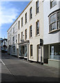
![Chepstow buildings [47]](https://s0.geograph.org.uk/geophotos/07/35/75/7357524_1ea5fe0a_120x120.jpg)
Chepstow buildings [47]
Number 11 Bank Street was built in the 18th century, remodelled in the 19th century and again in the 20th century. This small shop with accommodation above is constructed of Rendered rubble stone under a tile roof behind a plain cornice. Listed, grade II, with details at: https://cadwpublic-api.azurewebsites.net/reports/listedbuilding/FullReport?lang=&id=2491
Chepstow, the most easterly town in Wales, is located on the tidal River Wye, some 3 miles above its confluence with the River Severn. There is evidence of continuous human occupation from the Mesolithic period. The town grew in importance when the Normans erected a castle at what was the lowest bridging point of the River Wye. The town flourished as a port, being exempt from English taxation, and it mainly traded in timber and bark from the Wye Valley. The town became an important centre for tourism from the late eighteenth century.
Image: © Michael Dibb
Taken: 3 Sep 2022
0.00 miles
2
Chepstow - view up Bank Street
For an alternative view of this street, please see Image
Image: © Dave Bevis
Taken: 1 Oct 2011
0.00 miles
4
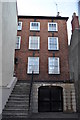
![Chepstow buildings [19]](https://s2.geograph.org.uk/geophotos/06/90/18/6901870_bf7bf11a_120x120.jpg)
Chepstow buildings [19]
Number 12 Bank Street is the former Bell Hotel now converted to offices and shops. Built in the 18th century of brick, now painted, with a slate roof. The hotel had operated on this site since at least 1763 until it closed in 1972. The former carriage entrance is now a through passage to shops and car park. Listed, grade II, with details at: https://cadwpublic-api.azurewebsites.net/reports/listedbuilding/FullReport?lang=&id=2492
Chepstow, the most easterly town in Wales, is located on the tidal River Wye, some 3 miles above its confluence with the River Severn. There is evidence of continuous human occupation from the Mesolithic period. The town grew in importance when the Normans erected a castle at what was the lowest bridging point of the River Wye. The town flourished as a port, being exempt from English taxation, and it mainly traded in timber and bark from the Wye Valley. The town became an important centre for tourism from the late eighteenth century.
Image: © Michael Dibb
Taken: 4 Jun 2021
0.00 miles
5
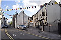
![Chepstow buildings [53]](https://s2.geograph.org.uk/geophotos/07/35/75/7357538_9da4074d_120x120.jpg)
Chepstow buildings [53]
Number 13 Bank Street has an early 19th century frontage to, or adjoining, an earlier building, shown by the corbelled corner, with a 19th century shopfront. Formerly an inn, the Lamb and Flag from 1766 to 1817, later The Wheatsheaf Inn. Constructed of stuccoed rubble stone under a slate roof. The side downhill has an elevation of rubble stone corbelled out at first floor level. Listed, grade II, with details at: https://cadwpublic-api.azurewebsites.net/reports/listedbuilding/FullReport?lang=&id=2493
Chepstow, the most easterly town in Wales, is located on the tidal River Wye, some 3 miles above its confluence with the River Severn. There is evidence of continuous human occupation from the Mesolithic period. The town grew in importance when the Normans erected a castle at what was the lowest bridging point of the River Wye. The town flourished as a port, being exempt from English taxation, and it mainly traded in timber and bark from the Wye Valley. The town became an important centre for tourism from the late eighteenth century.
Image: © Michael Dibb
Taken: 3 Sep 2022
0.01 miles
6
Junction of Bridge Street and Hocker Hill
Image: © Nick Mutton 01329 000000
Taken: 5 Jul 2010
0.01 miles
7
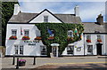
The Castle View Hotel
The Castle View Hotel,very colourful looking property
Image: © RAY JONES
Taken: 7 Jul 2009
0.01 miles
8
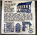
Chepstow - the Bush Inn plaque
This plaque is set into the pavement outside Woolworths, in the High Street.
Image: © Roy Parkhouse
Taken: 3 Jul 2007
0.02 miles
9
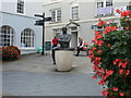
The Boatman, Chepstow
'Boatman' is a sculpture in two parts, consisting of a bronze figure of a man sitting on a stone boat with another smaller boat nearby. The sculptor was Andre Wallace, who was commissioned as part of the town centre regeneration scheme.
Image: © Eirian Evans
Taken: 30 Sep 2010
0.02 miles
10
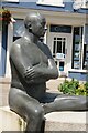
The Boatman
The Boatman sculpture was designed to reflect Chepstow's industrial heritage.
Image: © Philip Halling
Taken: 21 Jul 2021
0.02 miles