IMAGES TAKEN NEAR TO
CHEPSTOW, NP16 5DR
Introduction
This page details the photographs taken nearby to NP16 5DR by members of the Geograph project.
The Geograph project started in 2005 with the aim of publishing, organising and preserving representative images for every square kilometre of Great Britain, Ireland and the Isle of Man.

There are currently over 7.5m images from over14,400 individuals and you can help contribute to the project by visiting https://www.geograph.org.uk
Image Map
Images are licensed for reuse under creativecommons.org/licenses/by-sa/2.0
Notes
- Clicking on the map will re-center to the selected point.
- The higher the marker number, the further away the image location is from the centre of the postcode.
Image Listing (622 Images Found)
Images are licensed for reuse under creativecommons.org/licenses/by-sa/2.0
Image
Details
Distance
1
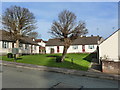
Sheltered Housing, Hardwick Avenue, Chepstow Garden City
Image: © Ruth Sharville
Taken: 22 Jan 2012
0.01 miles
2
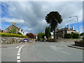
Junction of Hardwick Avenue, Rockwood Road and Garden City Way, Chepstow
Image: © Ruth Sharville
Taken: 14 May 2011
0.01 miles
3
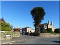
Junction of Rockwood Road and Hardwick Avenue, Chepstow Garden City
The space to the left of the house with the monkey puzzle tree is for sale for redevelopment, at time of photo (Oct 2018) after the house there was destroyed by fire.
Image: © Ruth Sharville
Taken: 22 Oct 2018
0.02 miles
4
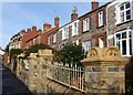
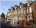
Terraced housing, Hardwick Avenue
Three different styles of house can be seen here, but all I reckon were built in the late 19th or early 20th century.
See Image
Image: © Ruth Sharville
Taken: 24 Jan 2009
0.03 miles
5
Terraced housing, Hardwick Avenue
These are the tallest houses in the terrace, located at the top of the (north west) end of the road.
Image: © Ruth Sharville
Taken: 24 Jan 2009
0.03 miles
6
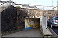
Underpass linking Garden City to the town centre
The main A48 runs above this underpass, and the parked car is at the end of Hardwick Avenue. Unfortunately, the attractive murals have recently been spoiled by graffiti.
Image: © Ruth Sharville
Taken: 24 Jan 2009
0.03 miles
7
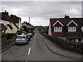
Green Street
Looking along Green Street in Garden City, Chepstow. At the very end you can see part of the port wall.
Image: © Mark Hobbs
Taken: 20 Jun 2011
0.04 miles
8
Junction of Green Street and Hardwick Avenue, Chepstow Garden City
Image: © Ruth Sharville
Taken: 22 Jan 2012
0.04 miles
9
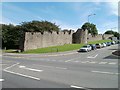
Part of the Port Wall, Garden City Way, Chepstow
On the eastern side of Garden City Way is a long section of the Port Wall http://www.geograph.org.uk/photo/545570 which enclosed medieval Chepstow.
Image: © Jaggery
Taken: 8 Sep 2010
0.05 miles
10
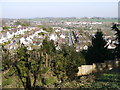
Chepstow Garden City from Mount Pleasant
This view has been made possible since the tops of the trees in the foreground were cut down. The straight road slightly to the right of centre is Green Street. In the distance can be seen houses in Beachley, on the other side of the River Wye in Gloucestershire.
Image: © Ruth Sharville
Taken: 27 Mar 2012
0.05 miles