IMAGES TAKEN NEAR TO
Thomas Street, CHEPSTOW, NP16 5DH
Introduction
This page details the photographs taken nearby to Thomas Street, NP16 5DH by members of the Geograph project.
The Geograph project started in 2005 with the aim of publishing, organising and preserving representative images for every square kilometre of Great Britain, Ireland and the Isle of Man.

There are currently over 7.5m images from over14,400 individuals and you can help contribute to the project by visiting https://www.geograph.org.uk
Image Map
Images are licensed for reuse under creativecommons.org/licenses/by-sa/2.0
Notes
- Clicking on the map will re-center to the selected point.
- The higher the marker number, the further away the image location is from the centre of the postcode.
Image Listing (796 Images Found)
Images are licensed for reuse under creativecommons.org/licenses/by-sa/2.0
Image
Details
Distance
1
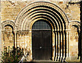
The west door of Chepstow St Mary
"A Guide to the Ancient Churches of Gwent" by Canon E.T. Davies has this to say: "The west door of Chepstow church is an excellent example of a Norman doorway with chevron ornamentation and recessed orders, which ultimately came to its present position after having been removed from the north porch"
Image: © Roy Parkhouse
Taken: 5 Apr 2006
0.00 miles
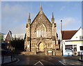
3
Chepstow Methodist Church
In the town centre, near the bus station.
Image: © Eirian Evans
Taken: 30 Sep 2010
0.01 miles
4
Chepstow Methodist Church
A church that likes plenty of flowers.
Image: © Neil Owen
Taken: 7 Aug 2013
0.01 miles
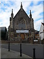
5
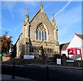
Chepstow Methodist Church
Part of the Chepstow and Caldicot Methodist Circuit, located in Albion Square, viewed across Thomas Street.
The building dates from the mid 19th century. The opening services were held on November 22nd 1855.
The building was Grade II listed in 1998.
Image: © Jaggery
Taken: 11 Nov 2016
0.01 miles
6
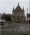
Grade II listed Chepstow Methodist Church
Part of the Chepstow and Caldicot Methodist Circuit, located in Albion Square.
The first services here were held on November 22nd 1855.
The building was Grade II listed in 1998.
Image: © Jaggery
Taken: 19 Feb 2018
0.01 miles
7
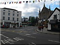
Chepstow Town Centre
Looking towards Thomas Street. The Methodist church is on the right, and the bus station just in front of the supermarket.
Image: © Eirian Evans
Taken: 30 Sep 2010
0.01 miles
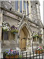
8
![Chepstow buildings [30]](https://s1.geograph.org.uk/geophotos/07/35/63/7356353_d7da9441_120x120.jpg)
Chepstow buildings [30]
Chepstow Methodist Church, Albion Square, was built in 1855 as a Wesleyan Methodist Church with later additions and alterations. Constructed in the Gothic Revival style, of coursed sandstone, with ashlar dressings under a slate roof. Listed, grade II, with details at: https://cadwpublic-api.azurewebsites.net/reports/listedbuilding/FullReport?lang=&id=20751
Chepstow, the most easterly town in Wales, is located on the tidal River Wye, some 3 miles above its confluence with the River Severn. There is evidence of continuous human occupation from the Mesolithic period. The town grew in importance when the Normans erected a castle at what was the lowest bridging point of the River Wye. The town flourished as a port, being exempt from English taxation, and it mainly traded in timber and bark from the Wye Valley. The town became an important centre for tourism from the late eighteenth century.
Image: © Michael Dibb
Taken: 2 Sep 2022
0.01 miles
9
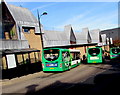
Three Newport Bus single deckers in Thomas Street, Chepstow
In 2016, Chepstow doesn't have a bus station as such. These stops in Thomas Street are where bus routes to and from Chepstow start and end. Newport Bus is the major provider of services in the Chepstow area, and also operates buses on two routes to and from Newport.
Image: © Jaggery
Taken: 11 Nov 2016
0.01 miles
10
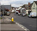
Thomas Street, Chepstow
Viewed from the corner of Regent Way. The bus is at Chepstow Bus Station.
Image: © Jaggery
Taken: 19 Feb 2018
0.01 miles